Srednyaya Akhtuba geodata
Srednyaya Akhtuba (Volgograd Oblast) is a populated place; located in Russia in Europe/Volgograd (GMT+3) time zone. With population of 13,887 people, there are 1150 cities with bigger population in this country. Compared to other cities in Russia, 79.4% of cities are located further ↑North; 50.3% of cities are located further →East and 93.3% of cities have higher elevation than Srednyaya Akhtuba. Note1


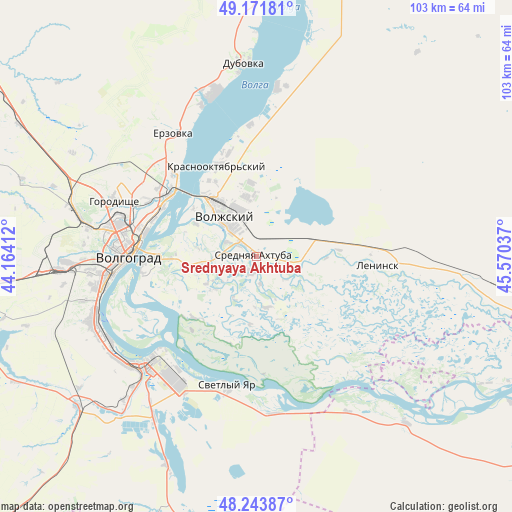
Srednyaya Akhtuba GPS coordinates[2]
48° 42' 35.928" North, 44° 52' 2.064" East
| Map corner | latitude | longitude |
|---|---|---|
| Upper-left | 49.17181°, | 44.16412° |
| Center: | 48.70998°, | 44.86724° |
| Lower-right: | 48.24387°, | 45.57037° |
| Map W x H: | 103.2×103.2 km | = 64.1×64.1mi |
| max Lat: | 73.50819° ⇑79.4% North |
| Srednyaya Akhtuba: | 48.70998° |
| min Lat: | ⇓20.6% South 41.28413° |
| min Long | Srednyaya Akhtu | max Long |
| -179.12198° | 44.86724° | 179.35046° |
| W 49.7%⇐ | ⇒50.3% E |
Elevation
Elevation of Srednyaya Akhtuba is 17 m = 56 ft, and this is 185.6 m = 609 ft below average elevation for this country.
| Max E: |
2518 m = 8261 ft | 93.3% |
| Avg. | 202.6 m = 665 ft | |
| Srednyaya Akhtuba | 17 m = 56 ft | |
Min E: |
-28 m = -92 ft | 6.7% |
See also: Russia elevation on elevation.city.
Geographical zone
Srednyaya Akhtuba is located in North temperate zone (between Tropic of Cancer and the Arctic Circle). Distance of this North polar circle is 1985.1 km =1233.5 mi to North.| Distance of | km | miles | from Srednyaya Akhtuba |
|---|---|---|---|
| North Pole | 4591 | 2852.7 | to North |
| Arctic Circle | 1985.1 | 1233.5 | to North |
| Tropic Cancer | 2810.1 | 1746.1 | to South |
| Equator | 5416 | 3365.3 | to South |


Nearby cities:
15 places around Srednyaya Akhtuba: (largest is in red/bold)
• Bereslavka
61.1 km =38 mi,  261°
261°
• Dubovka
38.8 km =24.1 mi,  355°
355°
• Gorodishche
30.7 km =19.1 mi,  290°
290°
• Gumrak
36.5 km =22.7 mi,  282°
282°
• Kapustin Yar
66 km =41 mi,  102°
102°
• Krasnoslobodsk
21.3 km =13.2 mi,  269°
269°
• Leninsk
24.3 km =15.1 mi,  92°
92°
• Novyy Rogachik
59.3 km =36.8 mi, 266°
• Primorsk
62.9 km =39.1 mi,  10°
10°
• Svetlyy Yar
26.9 km =16.7 mi,  193°
193°
• Vodstroy
27 km =16.8 mi,  302°
302°
• Volgograd
26.8 km =16.7 mi, 272°
• Volzhskiy
10.6 km =6.6 mi,  322°
322°
• Zaplavnoye
11.4 km =7.1 mi, 92°
• Znamensk
65.2 km =40.5 mi, 102°
Sources, notices
• [Note1] Compared only with cities in Russia existing in our database
• [Src1] Map data: © OpenStreetMap contributors (CC-BY-SA)
• [Src2] Other city data from geonames.org with taken over terms of usage.
• [Src3] Geographical zone / Annual Mean Temperature by Robert A. Rohde @ Wikipedia
