Yur’yevets geodata
Yur’yevets (Ivanovo) is a populated place; located in Russia in Europe/Moscow (GMT+3) time zone. With population of 11,488 people, there are 1326 cities with bigger population in this country. Compared to other cities in Russia, 79.2% of cities are located further ↓South; 56.2% of cities are located further →East and 57.3% of cities have higher elevation than Yur’yevets. Note1


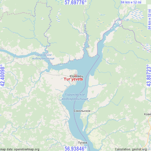
Yur’yevets GPS coordinates[2]
57° 19' 12.252" North, 43° 6' 14.76" East
| Map corner | latitude | longitude |
|---|---|---|
| Upper-left | 57.69776°, | 42.40098° |
| Center: | 57.32007°, | 43.1041° |
| Lower-right: | 56.93846°, | 43.80723° |
| Map W x H: | 84.4×84.4 km | = 52.4×52.4mi |
| max Lat: | 73.50819° ⇑20.8% North |
| Yur’yevets: | 57.32007° |
| min Lat: | ⇓79.2% South 41.28413° |
| min Long | Yur’yevets | max Long |
| -179.12198° | 43.1041° | 179.35046° |
| W 43.8%⇐ | ⇒56.2% E |
Elevation
Elevation of Yur’yevets is 130 m = 427 ft, and this is 72.6 m = 238 ft below average elevation for this country.
| Max E: |
2518 m = 8261 ft | 57.3% |
| Avg. | 202.6 m = 665 ft | |
| Yur’yevets | 130 m = 427 ft | |
Min E: |
-28 m = -92 ft | 42.7% |
See also: Russia elevation on elevation.city.
Geographical zone
Yur’yevets is located in North temperate zone (between Tropic of Cancer and the Arctic Circle). Distance of this North polar circle is 1027.8 km =638.6 mi to North.| Distance of | km | miles | from Yur’yevets |
|---|---|---|---|
| North Pole | 3633.7 | 2257.9 | to North |
| Arctic Circle | 1027.8 | 638.6 | to North |
| Tropic Cancer | 3767.5 | 2341 | to South |
| Equator | 6373.4 | 3960.2 | to South |


Nearby cities:
15 places around Yur’yevets: (largest is in red/bold)
• Chkalovsk
62.1 km =38.6 mi,  171°
171°
• Kadyy
52.2 km =32.4 mi,  5°
5°
• Katunki
54.8 km =34.1 mi, 172°
• Kineshma
59.9 km =37.2 mi,  282°
282°
• Kovernino
47.7 km =29.6 mi,  116°
116°
• Kuznechikha
47.7 km =29.6 mi,  255°
255°
• Lukh
61.4 km =38.2 mi,  236°
236°
• Navoloki
70.2 km =43.6 mi, 283°
• Puchezh
38.1 km =23.7 mi, 174°
• Sokol’skoye
20.2 km =12.6 mi, 170°
• Verkhniy Landekh
61.6 km =38.3 mi,  209°
209°
• Vichuga
71.6 km =44.5 mi, 260°
• Zarechnyy
51.8 km =32.2 mi,  288°
288°
• Zavolzhsk
60.6 km =37.7 mi, 287°
• Zavrazh’ye
10.6 km =6.6 mi,  19°
19°
Sources, notices
• [Note1] Compared only with cities in Russia existing in our database
• [Src1] Map data: © OpenStreetMap contributors (CC-BY-SA)
• [Src2] Other city data from geonames.org with taken over terms of usage.
• [Src3] Geographical zone / Annual Mean Temperature by Robert A. Rohde @ Wikipedia
