Kovernino geodata
Kovernino (Nizhny Novgorod Oblast) is a populated place; located in Russia in Europe/Moscow (GMT+3) time zone. With population of 6,988 people, there are 2004 cities with bigger population in this country. Compared to other cities in Russia, 78.1% of cities are located further ↓South; 53.4% of cities are located further →East and 61% of cities have higher elevation than Kovernino. Note1


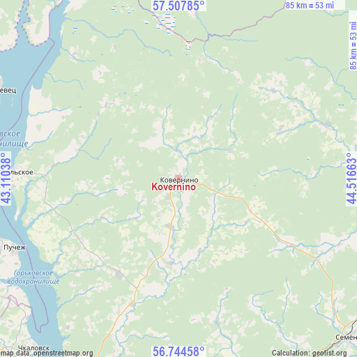
Kovernino GPS coordinates[2]
57° 7' 41.448" North, 43° 48' 48.6" East
| Map corner | latitude | longitude |
|---|---|---|
| Upper-left | 57.50785°, | 43.11038° |
| Center: | 57.12818°, | 43.8135° |
| Lower-right: | 56.74458°, | 44.51663° |
| Map W x H: | 84.9×84.9 km | = 52.8×52.8mi |
| max Lat: | 73.50819° ⇑21.9% North |
| Kovernino: | 57.12818° |
| min Lat: | ⇓78.1% South 41.28413° |
| min Long | Kovernino | max Long |
| -179.12198° | 43.8135° | 179.35046° |
| W 46.6%⇐ | ⇒53.4% E |
Elevation
Elevation of Kovernino is 122 m = 400 ft, and this is 80.6 m = 264 ft below average elevation for this country.
| Max E: |
2518 m = 8261 ft | 61% |
| Avg. | 202.6 m = 665 ft | |
| Kovernino | 122 m = 400 ft | |
Min E: |
-28 m = -92 ft | 39% |
See also: Russia elevation on elevation.city.
Geographical zone
Kovernino is located in North temperate zone (between Tropic of Cancer and the Arctic Circle). Distance of this North polar circle is 1049.1 km =651.9 mi to North.| Distance of | km | miles | from Kovernino |
|---|---|---|---|
| North Pole | 3655 | 2271.1 | to North |
| Arctic Circle | 1049.1 | 651.9 | to North |
| Tropic Cancer | 3746.1 | 2327.7 | to South |
| Equator | 6352.1 | 3947 | to South |


Nearby cities:
15 places around Kovernino: (largest is in red/bold)
• Chkalovsk
52.6 km =32.7 mi,  220°
220°
• Gidrotorf
74.5 km =46.3 mi,  193°
193°
• Gorodets
56.5 km =35.1 mi,  201°
201°
• Katunki
48.8 km =30.3 mi,  227°
227°
• Linda
59.5 km =37 mi,  163°
163°
• Novaya Balakhna
72.1 km =44.8 mi, 190°
• Pervomayskiy
63.4 km =39.4 mi,  205°
205°
• Puchezh
42.4 km =26.3 mi,  246°
246°
• Purekh
70.1 km =43.6 mi, 220°
• Semënov
56 km =34.8 mi,  132°
132°
• Sokol’skoye
39.5 km =24.5 mi,  272°
272°
• Sukhobezvodnoye
65.6 km =40.8 mi,  97°
97°
• Yur’yevets
47.7 km =29.6 mi,  296°
296°
• Zavolzh’ye
59.9 km =37.2 mi, 205°
• Zavrazh’ye
50.1 km =31.1 mi,  308°
308°
Sources, notices
• [Note1] Compared only with cities in Russia existing in our database
• [Src1] Map data: © OpenStreetMap contributors (CC-BY-SA)
• [Src2] Other city data from geonames.org with taken over terms of usage.
• [Src3] Geographical zone / Annual Mean Temperature by Robert A. Rohde @ Wikipedia
