Kuznechikha geodata
Kuznechikha (Ivanovo) is a populated place; located in Russia in Europe/Moscow (GMT+3) time zone. With population of 3,227 people, there are 3586 cities with bigger population in this country. Compared to other cities in Russia, 78.6% of cities are located further ↓South; 58.7% of cities are located further →East and 60% of cities have higher elevation than Kuznechikha. Note1


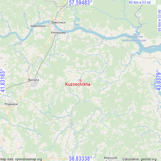
Kuznechikha GPS coordinates[2]
57° 12' 57.852" North, 42° 20' 5.172" East
| Map corner | latitude | longitude |
|---|---|---|
| Upper-left | 57.59483°, | 41.63165° |
| Center: | 57.21607°, | 42.33477° |
| Lower-right: | 56.83338°, | 43.0379° |
| Map W x H: | 84.7×84.7 km | = 52.6×52.6mi |
| max Lat: | 73.50819° ⇑21.4% North |
| Kuznechikha: | 57.21607° |
| min Lat: | ⇓78.6% South 41.28413° |
| min Long | Kuznechikha | max Long |
| -179.12198° | 42.33477° | 179.35046° |
| W 41.3%⇐ | ⇒58.7% E |
Elevation
Elevation of Kuznechikha is 124 m = 407 ft, and this is 78.6 m = 258 ft below average elevation for this country.
| Max E: |
2518 m = 8261 ft | 60% |
| Avg. | 202.6 m = 665 ft | |
| Kuznechikha | 124 m = 407 ft | |
Min E: |
-28 m = -92 ft | 40% |
See also: Russia elevation on elevation.city.
Geographical zone
Kuznechikha is located in North temperate zone (between Tropic of Cancer and the Arctic Circle). Distance of this North polar circle is 1039.3 km =645.8 mi to North.| Distance of | km | miles | from Kuznechikha |
|---|---|---|---|
| North Pole | 3645.2 | 2265 | to North |
| Arctic Circle | 1039.3 | 645.8 | to North |
| Tropic Cancer | 3755.9 | 2333.8 | to South |
| Equator | 6361.8 | 3953 | to South |


Nearby cities:
15 places around Kuznechikha: (largest is in red/bold)
• Kamenka
37.9 km =23.5 mi,  301°
301°
• Kaminskiy
52.4 km =32.6 mi,  262°
262°
• Kineshma
27.7 km =17.2 mi,  333°
333°
• Lukh
23.1 km =14.4 mi,  191°
191°
• Navoloki
35.6 km =22.1 mi,  321°
321°
• Novopistsovo
31.3 km =19.4 mi,  292°
292°
• Rodniki
38.5 km =23.9 mi,  251°
251°
• Sokol’skoye
50.4 km =31.3 mi,  99°
99°
• Staraya Vichuga
28 km =17.4 mi,  281°
281°
• Verkhniy Landekh
44.8 km =27.8 mi,  159°
159°
• Vichuga
24.4 km =15.2 mi,  269°
269°
• Yur’yevets
47.7 km =29.6 mi,  75°
75°
• Zarechnyy
28.3 km =17.6 mi,  353°
353°
• Zavolzhsk
31.9 km =19.8 mi,  338°
338°
• Zavrazh’ye
54.2 km =33.7 mi,  66°
66°
Sources, notices
• [Note1] Compared only with cities in Russia existing in our database
• [Src1] Map data: © OpenStreetMap contributors (CC-BY-SA)
• [Src2] Other city data from geonames.org with taken over terms of usage.
• [Src3] Geographical zone / Annual Mean Temperature by Robert A. Rohde @ Wikipedia
