Yelkhovka geodata
Yelkhovka (Samara Oblast) is a populated place; located in Russia in Europe/Samara (GMT+4) time zone. With population of 3,142 people, there are 3656 cities with bigger population in this country. Compared to other cities in Russia, 56.3% of cities are located further ↑North; 62.4% of cities are located further ←West and 82.4% of cities have higher elevation than Yelkhovka. Note1


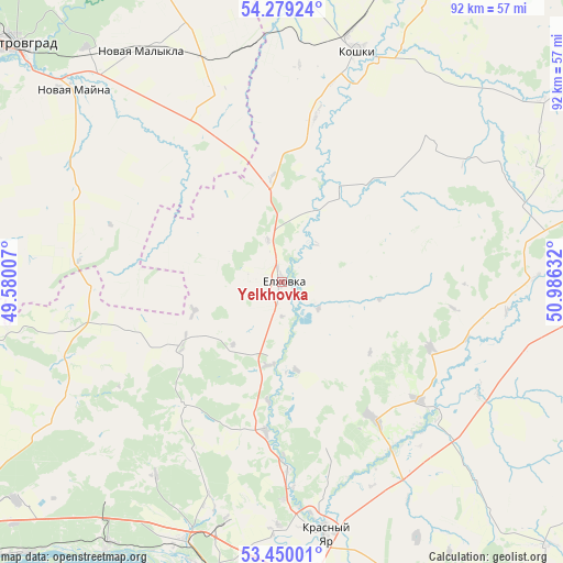
Yelkhovka GPS coordinates[2]
53° 52' 0.048" North, 50° 16' 59.484" East
| Map corner | latitude | longitude |
|---|---|---|
| Upper-left | 54.27924°, | 49.58007° |
| Center: | 53.86668°, | 50.28319° |
| Lower-right: | 53.45001°, | 50.98632° |
| Map W x H: | 92.2×92.2 km | = 57.3×57.3mi |
| max Lat: | 73.50819° ⇑56.3% North |
| Yelkhovka: | 53.86668° |
| min Lat: | ⇓43.7% South 41.28413° |
| min Long | Yelkhovka | max Long |
| -179.12198° | 50.28319° | 179.35046° |
| W 62.4%⇐ | ⇒37.6% E |
Elevation
Elevation of Yelkhovka is 61 m = 200 ft, and this is 141.6 m = 465 ft below average elevation for this country.
| Max E: |
2518 m = 8261 ft | 82.4% |
| Avg. | 202.6 m = 665 ft | |
| Yelkhovka | 61 m = 200 ft | |
Min E: |
-28 m = -92 ft | 17.6% |
See also: Russia elevation on elevation.city.
Geographical zone
Yelkhovka is located in North temperate zone (between Tropic of Cancer and the Arctic Circle). Distance of this North polar circle is 1411.8 km =877.3 mi to North.| Distance of | km | miles | from Yelkhovka |
|---|---|---|---|
| North Pole | 4017.6 | 2496.4 | to North |
| Arctic Circle | 1411.8 | 877.3 | to North |
| Tropic Cancer | 3383.5 | 2102.4 | to South |
| Equator | 5989.4 | 3721.6 | to South |


Nearby cities:
15 places around Yelkhovka: (largest is in red/bold)
• Berëza
39.9 km =24.8 mi,  193°
193°
• Bogatyr’
53.4 km =33.2 mi,  204°
204°
• Koshki
39.9 km =24.8 mi,  17°
17°
• Krasnyy Yar
41.4 km =25.7 mi,  169°
169°
• Kurumoch
44.9 km =27.9 mi, 201°
• Mirnyy
40.1 km =24.9 mi,  180°
180°
• Novaya Malykla
43 km =26.7 mi,  329°
329°
• Novaya Mayna
47 km =29.2 mi,  312°
312°
• Novocheremshansk
55.1 km =34.2 mi,  352°
352°
• Novosemeykino
55.4 km =34.4 mi, 175°
• Novyy Buyan
25.4 km =15.8 mi,  217°
217°
• Povolzhskiy
46.4 km =28.8 mi,  227°
227°
• Pribrezhnyy
50.7 km =31.5 mi,  213°
213°
• Volzhskiy
49.7 km =30.9 mi, 192°
• Zol’noye
57 km =35.4 mi, 214°
Sources, notices
• [Note1] Compared only with cities in Russia existing in our database
• [Src1] Map data: © OpenStreetMap contributors (CC-BY-SA)
• [Src2] Other city data from geonames.org with taken over terms of usage.
• [Src3] Geographical zone / Annual Mean Temperature by Robert A. Rohde @ Wikipedia
