Pribrezhnyy geodata
Pribrezhnyy (Samara Oblast) is a populated place; located in Russia in Europe/Samara (GMT+4) time zone. With population of 11,500 people, there are 1324 cities with bigger population in this country. Compared to other cities in Russia, 58.9% of cities are located further ↑North; 61.7% of cities are located further ←West and 62.4% of cities have lower elevation than Pribrezhnyy. Note1


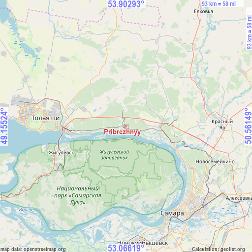
Pribrezhnyy GPS coordinates[2]
53° 29' 11.832" North, 49° 51' 30.096" East
| Map corner | latitude | longitude |
|---|---|---|
| Upper-left | 53.90293°, | 49.15524° |
| Center: | 53.48662°, | 49.85836° |
| Lower-right: | 53.06619°, | 50.56149° |
| Map W x H: | 93×93 km | = 57.8×57.8mi |
| max Lat: | 73.50819° ⇑58.9% North |
| Pribrezhnyy: | 53.48662° |
| min Lat: | ⇓41.1% South 41.28413° |
| min Long | Pribrezhnyy | max Long |
| -179.12198° | 49.85836° | 179.35046° |
| W 61.7%⇐ | ⇒38.3% E |
Elevation
Elevation of Pribrezhnyy is 175 m = 574 ft, and this is 27.6 m = 91 ft below average elevation for this country.
| Max E: |
2518 m = 8261 ft | 37.6% |
| Avg. | 202.6 m = 665 ft | |
| Pribrezhnyy | 175 m = 574 ft | |
Min E: |
-28 m = -92 ft | 62.4% |
See also: Russia elevation on elevation.city.
Geographical zone
Pribrezhnyy is located in North temperate zone (between Tropic of Cancer and the Arctic Circle). Distance of this North polar circle is 1454 km =903.5 mi to North.| Distance of | km | miles | from Pribrezhnyy |
|---|---|---|---|
| North Pole | 4059.9 | 2522.7 | to North |
| Arctic Circle | 1454 | 903.5 | to North |
| Tropic Cancer | 3341.2 | 2076.1 | to South |
| Equator | 5947.2 | 3695.4 | to South |


Nearby cities:
15 places around Pribrezhnyy: (largest is in red/bold)
• Bakhilovo
17.5 km =10.9 mi,  237°
237°
• Berëza
18.9 km =11.7 mi,  79°
79°
• Bogatyr’
8.6 km =5.3 mi,  137°
137°
• Krasnyy Yar
35.4 km =22 mi,  87°
87°
• Kurumoch
11.9 km =7.4 mi, 88°
• Mirnyy
27.7 km =17.2 mi, 85°
• Novosemeykino
35.3 km =21.9 mi,  111°
111°
• Novyy Buyan
25.4 km =15.8 mi,  29°
29°
• Povolzhskiy
12.7 km =7.9 mi,  330°
330°
• Rozhdestveno
30.8 km =19.1 mi,  154°
154°
• Tol’yatti
34.2 km =21.3 mi,  278°
278°
• Valy
35 km =21.7 mi, 239°
• Volzhskiy
18.3 km =11.4 mi, 109°
• Zhigulevsk
25.9 km =16.1 mi,  248°
248°
• Zol’noye
6.4 km =4 mi,  219°
219°
Sources, notices
• [Note1] Compared only with cities in Russia existing in our database
• [Src1] Map data: © OpenStreetMap contributors (CC-BY-SA)
• [Src2] Other city data from geonames.org with taken over terms of usage.
• [Src3] Geographical zone / Annual Mean Temperature by Robert A. Rohde @ Wikipedia
