Zol’noye geodata
Zol’noye (Samara Oblast) is a populated place; located in Russia in Europe/Samara (GMT+4) time zone. With population of 1,614 people, there are 4328 cities with bigger population in this country. Compared to other cities in Russia, 59.2% of cities are located further ↑North; 61.7% of cities are located further ←West and 72.2% of cities have higher elevation than Zol’noye. Note1


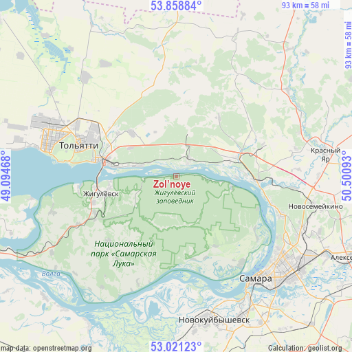
Zol’noye GPS coordinates[2]
53° 26' 31.56" North, 49° 47' 52.08" East
| Map corner | latitude | longitude |
|---|---|---|
| Upper-left | 53.85884°, | 49.09468° |
| Center: | 53.4421°, | 49.7978° |
| Lower-right: | 53.02123°, | 50.50093° |
| Map W x H: | 93.1×93.1 km | = 57.8×57.8mi |
| max Lat: | 73.50819° ⇑59.2% North |
| Zol’noye: | 53.4421° |
| min Lat: | ⇓40.8% South 41.28413° |
| min Long | Zol’noye | max Long |
| -179.12198° | 49.7978° | 179.35046° |
| W 61.7%⇐ | ⇒38.3% E |
Elevation
Elevation of Zol’noye is 97 m = 318 ft, and this is 105.6 m = 346 ft below average elevation for this country.
| Max E: |
2518 m = 8261 ft | 72.2% |
| Avg. | 202.6 m = 665 ft | |
| Zol’noye | 97 m = 318 ft | |
Min E: |
-28 m = -92 ft | 27.8% |
See also: Russia elevation on elevation.city.
Geographical zone
Zol’noye is located in North temperate zone (between Tropic of Cancer and the Arctic Circle). Distance of this North polar circle is 1459 km =906.6 mi to North.| Distance of | km | miles | from Zol’noye |
|---|---|---|---|
| North Pole | 4064.9 | 2525.8 | to North |
| Arctic Circle | 1459 | 906.6 | to North |
| Tropic Cancer | 3336.3 | 2073.1 | to South |
| Equator | 5942.2 | 3692.3 | to South |


Nearby cities:
15 places around Zol’noye: (largest is in red/bold)
• Bakhilovo
11.6 km =7.2 mi,  246°
246°
• Berëza
24.2 km =15 mi,  69°
69°
• Bogatyr’
9.9 km =6.2 mi,  97°
97°
• Kurumoch
16.7 km =10.4 mi, 71°
• Mirnyy
32.5 km =20.2 mi,  77°
77°
• Novyy Buyan
31.7 km =19.7 mi,  31°
31°
• Povolzhskiy
16.1 km =10 mi,  351°
351°
• Pribrezhnyy
6.4 km =4 mi,  39°
39°
• Rozhdestveno
28.6 km =17.8 mi,  142°
142°
• Samara
35.7 km =22.2 mi, 139°
• Tol’yatti
31.5 km =19.6 mi,  288°
288°
• Valy
29.1 km =18.1 mi,  243°
243°
• Volzhskiy
21.3 km =13.2 mi,  93°
93°
• Zhigulevsk
20.6 km =12.8 mi,  256°
256°
• Zhiguli
34.2 km =21.3 mi, 254°
Sources, notices
• [Note1] Compared only with cities in Russia existing in our database
• [Src1] Map data: © OpenStreetMap contributors (CC-BY-SA)
• [Src2] Other city data from geonames.org with taken over terms of usage.
• [Src3] Geographical zone / Annual Mean Temperature by Robert A. Rohde @ Wikipedia
