Vologda geodata
Vologda is a seat of a first-order administrative division; located in Russia in Europe/Moscow (GMT+3) time zone. With population of 314,900 people, there are 62 cities with bigger population in this country. Compared to other cities in Russia, 87.1% of cities are located further ↓South; 68.1% of cities are located further →East and 59.6% of cities have higher elevation than Vologda. Note1


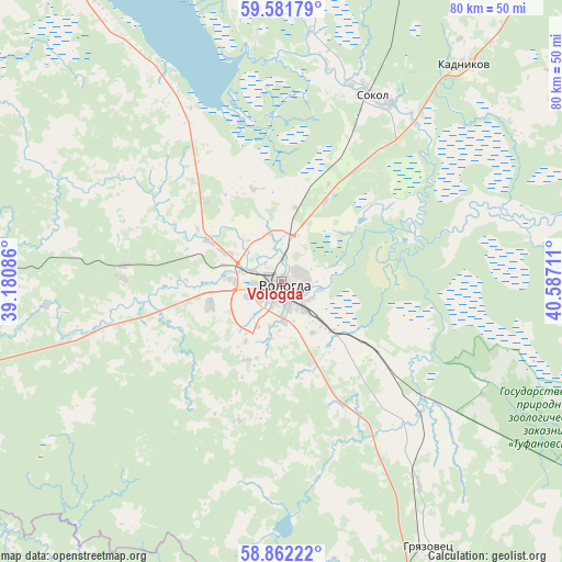
Vologda GPS coordinates[2]
59° 13' 26.04" North, 39° 53' 2.328" East
| Map corner | latitude | longitude |
|---|---|---|
| Upper-left | 59.58179°, | 39.18086° |
| Center: | 59.2239°, | 39.88398° |
| Lower-right: | 58.86222°, | 40.58711° |
| Map W x H: | 80×80 km | = 49.7×49.7mi |
| max Lat: | 73.50819° ⇑12.9% North |
| Vologda: | 59.2239° |
| min Lat: | ⇓87.1% South 41.28413° |
| min Long | Vologda | max Long |
| -179.12198° | 39.88398° | 179.35046° |
| W 31.9%⇐ | ⇒68.1% E |
Elevation
Elevation of Vologda is 125 m = 410 ft, and this is 77.6 m = 255 ft below average elevation for this country.
| Max E: |
2518 m = 8261 ft | 59.6% |
| Avg. | 202.6 m = 665 ft | |
| Vologda | 125 m = 410 ft | |
Min E: |
-28 m = -92 ft | 40.4% |
See also: Vologda elevation on elevation.city.
Geographical zone
Vologda is located in North temperate zone (between Tropic of Cancer and the Arctic Circle). Distance of this North polar circle is 816.1 km =507.1 mi to North.| Distance of | km | miles | from Vologda |
|---|---|---|---|
| North Pole | 3422 | 2126.3 | to North |
| Arctic Circle | 816.1 | 507.1 | to North |
| Tropic Cancer | 3979.2 | 2472.6 | to South |
| Equator | 6585.1 | 4091.8 | to South |


Nearby cities:
15 places around Vologda: (largest is in red/bold)
• Chebsara
59.7 km =37.1 mi,  267°
267°
• Gryazovets
43.7 km =27.2 mi,  151°
151°
• Kadnikov
40.2 km =25 mi,  39°
39°
• Kharovsk
84.1 km =52.3 mi,  11°
11°
• Kukoboy
58.2 km =36.2 mi,  178°
178°
• Lyubim
106.3 km =66.1 mi, 154°
• Molochnoye
13.9 km =8.6 mi,  302°
302°
• Myaksa
103.6 km =64.4 mi,  248°
248°
• Poshekhon’ye
91.3 km =56.7 mi,  208°
208°
• Prechistoye
93.1 km =57.8 mi,  163°
163°
• Sheksna
78.2 km =48.6 mi, 268°
• Shuyskoye
67.2 km =41.8 mi,  75°
75°
• Sokol
29.6 km =18.4 mi,  26°
26°
• Ust’ye
46 km =28.6 mi,  349°
349°
• Vokhtoga
81.7 km =50.8 mi,  124°
124°
Sources, notices
• [Note1] Compared only with cities in Russia existing in our database
• [Src1] Map data: © OpenStreetMap contributors (CC-BY-SA)
• [Src2] Other city data from geonames.org with taken over terms of usage.
• [Src3] Geographical zone / Annual Mean Temperature by Robert A. Rohde @ Wikipedia
