Verkhneural’sk geodata
Verkhneural’sk (Chelyabinsk) is a populated place; located in Russia in Asia/Yekaterinburg (GMT+5) time zone. With population of 10,267 people, there are 1472 cities with bigger population in this country. Compared to other cities in Russia, 56.2% of cities are located further ↑North; 70.6% of cities are located further ←West and 88.4% of cities have lower elevation than Verkhneural’sk. Note1


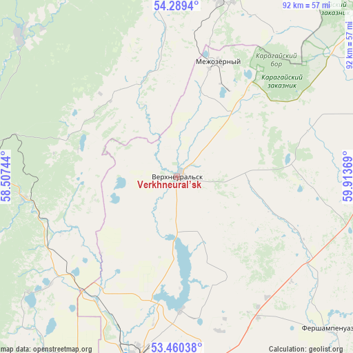
Verkhneural’sk GPS coordinates[2]
53° 52' 36.984" North, 59° 12' 38.016" East
| Map corner | latitude | longitude |
|---|---|---|
| Upper-left | 54.2894°, | 58.50744° |
| Center: | 53.87694°, | 59.21056° |
| Lower-right: | 53.46038°, | 59.91369° |
| Map W x H: | 92.2×92.2 km | = 57.3×57.3mi |
| max Lat: | 73.50819° ⇑56.2% North |
| Verkhneural’sk: | 53.87694° |
| min Lat: | ⇓43.8% South 41.28413° |
| min Long | Verkhneural’s | max Long |
| -179.12198° | 59.21056° | 179.35046° |
| W 70.6%⇐ | ⇒29.4% E |
Elevation
Elevation of Verkhneural’sk is 408 m = 1339 ft, and this is 205.4 m = 674 ft above average elevation for this country.
| Max E: |
2518 m = 8261 ft | 11.6% |
| Verkhneural’sk | 408 m 1339 ft | |
| Avg. | 202.6 m = 665 ft | |
Min E: |
-28 m = -92 ft | 88.4% |
See also: Russia elevation on elevation.city.
Geographical zone
Verkhneural’sk is located in North temperate zone (between Tropic of Cancer and the Arctic Circle). Distance of this North polar circle is 1410.6 km =876.5 mi to North.| Distance of | km | miles | from Verkhneural’sk |
|---|---|---|---|
| North Pole | 4016.5 | 2495.7 | to North |
| Arctic Circle | 1410.6 | 876.5 | to North |
| Tropic Cancer | 3384.6 | 2103.1 | to South |
| Equator | 5990.6 | 3722.4 | to South |


Nearby cities:
15 places around Verkhneural’sk: (largest is in red/bold)
• Abzakovo
40.8 km =25.4 mi,  262°
262°
• Agapovka
64.6 km =40.1 mi,  184°
184°
• Akhunovo
44.8 km =27.8 mi,  34°
34°
• Beloretsk
54.1 km =33.6 mi,  280°
280°
• Fershampenuaz
56 km =34.8 mi,  135°
135°
• Kassel’skiy
24.9 km =15.5 mi,  109°
109°
• Lomovka
55.5 km =34.5 mi,  274°
274°
• Magnitogorsk
52.1 km =32.4 mi,  191°
191°
• Mezgor'e
93.2 km =57.9 mi, 281°
• Mindyak
32 km =19.9 mi,  300°
300°
• Mishkino
15.3 km =9.5 mi,  333°
333°
• Parizh
87.2 km =54.2 mi, 137°
• Tirlyanskiy
55.4 km =34.4 mi,  312°
312°
• Uchaly
55.5 km =34.5 mi,  15°
15°
• Uyskoye
76 km =47.2 mi,  42°
42°
Sources, notices
• [Note1] Compared only with cities in Russia existing in our database
• [Src1] Map data: © OpenStreetMap contributors (CC-BY-SA)
• [Src2] Other city data from geonames.org with taken over terms of usage.
• [Src3] Geographical zone / Annual Mean Temperature by Robert A. Rohde @ Wikipedia
