Lomovka geodata
Lomovka (Bashkortostan Republic) is a populated place; located in Russia in Asia/Yekaterinburg (GMT+5) time zone. With population of 3,178 people, there are 3626 cities with bigger population in this country. Compared to other cities in Russia, 56% of cities are located further ↑North; 69.9% of cities are located further ←West and 92% of cities have lower elevation than Lomovka. Note1


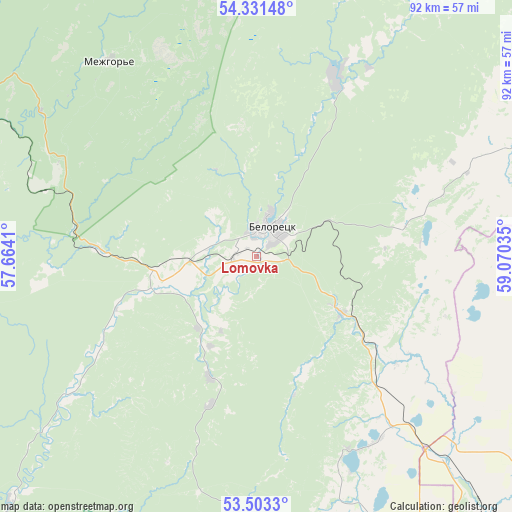
Lomovka GPS coordinates[2]
53° 55' 9.984" North, 58° 22' 1.992" East
| Map corner | latitude | longitude |
|---|---|---|
| Upper-left | 54.33148°, | 57.6641° |
| Center: | 53.91944°, | 58.36722° |
| Lower-right: | 53.5033°, | 59.07035° |
| Map W x H: | 92.1×92.1 km | = 57.2×57.2mi |
| max Lat: | 73.50819° ⇑56% North |
| Lomovka: | 53.91944° |
| min Lat: | ⇓44% South 41.28413° |
| min Long | Lomovka | max Long |
| -179.12198° | 58.36722° | 179.35046° |
| W 69.9%⇐ | ⇒30.1% E |
Elevation
Elevation of Lomovka is 506 m = 1660 ft, and this is 303.4 m = 995 ft above average elevation for this country.
| Max E: |
2518 m = 8261 ft | 8% |
| Lomovka | 506 m 1660 ft | |
| Avg. | 202.6 m = 665 ft | |
Min E: |
-28 m = -92 ft | 92% |
See also: Russia elevation on elevation.city.
Geographical zone
Lomovka is located in North temperate zone (between Tropic of Cancer and the Arctic Circle). Distance of this North polar circle is 1405.9 km =873.6 mi to North.| Distance of | km | miles | from Lomovka |
|---|---|---|---|
| North Pole | 4011.8 | 2492.8 | to North |
| Arctic Circle | 1405.9 | 873.6 | to North |
| Tropic Cancer | 3389.4 | 2106.1 | to South |
| Equator | 5995.3 | 3725.3 | to South |


Nearby cities:
15 places around Lomovka: (largest is in red/bold)
• Abzakovo
17.9 km =11.1 mi,  124°
124°
• Agapovka
85.7 km =53.3 mi,  143°
143°
• Akhunovo
86.7 km =53.9 mi,  68°
68°
• Beloretsk
5.3 km =3.3 mi,  22°
22°
• Inzer
62.4 km =38.8 mi,  301°
301°
• Kassel’skiy
79.9 km =49.6 mi,  99°
99°
• Magnitogorsk
71.5 km =44.4 mi, 141°
• Mezgor'e
38.8 km =24.1 mi,  291°
291°
• Mindyak
29.9 km =18.6 mi, 67°
• Mishkino
49.2 km =30.6 mi,  79°
79°
• Tirlyanskiy
35.3 km =21.9 mi, 23°
• Tukan
60.4 km =37.5 mi,  261°
261°
• Uchaly
85 km =52.8 mi,  54°
54°
• Verkhneural’sk
55.5 km =34.5 mi,  94°
94°
• Verkhniy Avzyan
69.8 km =43.4 mi,  231°
231°
Sources, notices
• [Note1] Compared only with cities in Russia existing in our database
• [Src1] Map data: © OpenStreetMap contributors (CC-BY-SA)
• [Src2] Other city data from geonames.org with taken over terms of usage.
• [Src3] Geographical zone / Annual Mean Temperature by Robert A. Rohde @ Wikipedia
