Utta geodata
Utta (Kalmykiya Republic) is a populated place; located in Russia in Europe/Moscow (GMT+3) time zone. With population of 806 people, there are 4749 cities with bigger population in this country. Compared to other cities in Russia, 83.3% of cities are located further ↑North; 52.8% of cities are located further ←West and 99.3% of cities have higher elevation than Utta. Note1


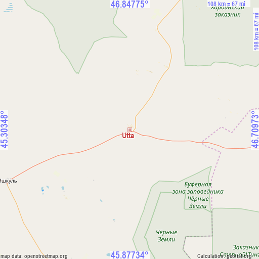
Utta GPS coordinates[2]
46° 21' 52.92" North, 46° 0' 23.76" East
| Map corner | latitude | longitude |
|---|---|---|
| Upper-left | 46.84775°, | 45.30348° |
| Center: | 46.3647°, | 46.0066° |
| Lower-right: | 45.87734°, | 46.70973° |
| Map W x H: | 107.9×107.9 km | = 67×67mi |
| max Lat: | 73.50819° ⇑83.3% North |
| Utta: | 46.3647° |
| min Lat: | ⇓16.7% South 41.28413° |
| min Long | Utta | max Long |
| -179.12198° | 46.0066° | 179.35046° |
| W 52.8%⇐ | ⇒47.2% E |
Elevation
Elevation of Utta is -11 m = -36 ft, and this is 213.6 m = 701 ft below average elevation for this country.
| Max E: |
2518 m = 8261 ft | 99.3% |
| Avg. | 202.6 m = 665 ft | |
| Utta | -11 m = -36 ft | |
Min E: |
-28 m = -92 ft | 0.7% |
See also: Russia elevation on elevation.city.
Geographical zone
Utta is located in North temperate zone (between Tropic of Cancer and the Arctic Circle). Distance of this North polar circle is 2245.9 km =1395.5 mi to North.| Distance of | km | miles | from Utta |
|---|---|---|---|
| North Pole | 4851.8 | 3014.8 | to North |
| Arctic Circle | 2245.9 | 1395.5 | to North |
| Tropic Cancer | 2549.4 | 1584.1 | to South |
| Equator | 5155.3 | 3203.4 | to South |


Nearby cities:
15 places around Utta: (largest is in red/bold)
• Arshan’
137.6 km =85.5 mi,  265°
265°
• Elista
134.5 km =83.6 mi, 267°
• Iki-Burul
121 km =75.2 mi,  240°
240°
• Ikryanoye
136 km =84.5 mi,  102°
102°
• Komsomol’skiy
115.1 km =71.5 mi,  178°
178°
• Krasnyye Barrikady
143 km =88.9 mi, 97°
• Liman
113.9 km =70.8 mi,  124°
124°
• Mumra
143.1 km =88.9 mi, 117°
• Oranzherei
133.3 km =82.8 mi, 115°
• Troitskoye
134.2 km =83.4 mi, 272°
• Trudfront
136.7 km =84.9 mi,  110°
110°
• Yandyki
108.8 km =67.6 mi,  127°
127°
• Yashkul’
55.3 km =34.4 mi,  247°
247°
• Yenotayevka
125 km =77.7 mi,  38°
38°
• Zenzeli
94 km =58.4 mi, 121°
Sources, notices
• [Note1] Compared only with cities in Russia existing in our database
• [Src1] Map data: © OpenStreetMap contributors (CC-BY-SA)
• [Src2] Other city data from geonames.org with taken over terms of usage.
• [Src3] Geographical zone / Annual Mean Temperature by Robert A. Rohde @ Wikipedia
