Yenotayevka geodata
Yenotayevka (Astrakhan) is a populated place; located in Russia in Europe/Astrakhan (GMT+4) time zone. With population of 7,985 people, there are 1805 cities with bigger population in this country. Compared to other cities in Russia, 81.8% of cities are located further ↑North; 56% of cities are located further ←West and 99.2% of cities have higher elevation than Yenotayevka. Note1


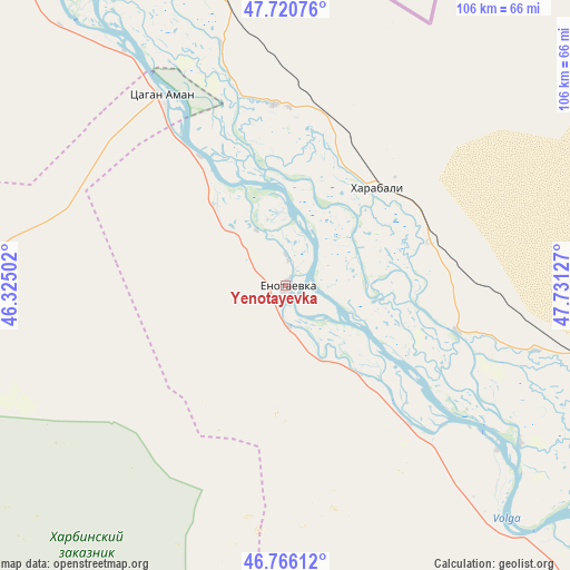
Yenotayevka GPS coordinates[2]
47° 14' 44.124" North, 47° 1' 41.304" East
| Map corner | latitude | longitude |
|---|---|---|
| Upper-left | 47.72076°, | 46.32502° |
| Center: | 47.24559°, | 47.02814° |
| Lower-right: | 46.76612°, | 47.73127° |
| Map W x H: | 106.1×106.1 km | = 65.9×65.9mi |
| max Lat: | 73.50819° ⇑81.8% North |
| Yenotayevka: | 47.24559° |
| min Lat: | ⇓18.2% South 41.28413° |
| min Long | Yenotayevka | max Long |
| -179.12198° | 47.02814° | 179.35046° |
| W 56%⇐ | ⇒44% E |
Elevation
Elevation of Yenotayevka is -8 m = -26 ft, and this is 210.6 m = 691 ft below average elevation for this country.
| Max E: |
2518 m = 8261 ft | 99.2% |
| Avg. | 202.6 m = 665 ft | |
| Yenotayevka | -8 m = -26 ft | |
Min E: |
-28 m = -92 ft | 0.8% |
See also: Russia elevation on elevation.city.
Geographical zone
Yenotayevka is located in North temperate zone (between Tropic of Cancer and the Arctic Circle). Distance of this North polar circle is 2148 km =1334.7 mi to North.| Distance of | km | miles | from Yenotayevka |
|---|---|---|---|
| North Pole | 4753.8 | 2953.9 | to North |
| Arctic Circle | 2148 | 1334.7 | to North |
| Tropic Cancer | 2647.3 | 1645 | to South |
| Equator | 5253.2 | 3264.2 | to South |


Nearby cities:
15 places around Yenotayevka: (largest is in red/bold)
• Aksarayskiy
90 km =55.9 mi,  124°
124°
• Astrakhan
126 km =78.3 mi,  142°
142°
• Chyorny Yar
114 km =70.8 mi,  322°
322°
• Kharabali
25.9 km =16.1 mi,  41°
41°
• Krasnyy Yar
127.7 km =79.3 mi,  128°
128°
• Mirnyy
118 km =73.3 mi, 144°
• Narimanov
87.6 km =54.4 mi, 134°
• Nizhniy Baskunchak
109.3 km =67.9 mi,  352°
352°
• Sasykoli
34.1 km =21.2 mi,  356°
356°
• Solyanka
121.4 km =75.4 mi, 141°
• Starokucherganovka
124.4 km =77.3 mi,  145°
145°
• Tambovka
27.5 km =17.1 mi,  73°
73°
• Tsagan Aman
42.2 km =26.2 mi,  326°
326°
• Utta
125 km =77.7 mi,  218°
218°
• Verkhniy Baskunchak
111.4 km =69.2 mi, 348°
Sources, notices
• [Note1] Compared only with cities in Russia existing in our database
• [Src1] Map data: © OpenStreetMap contributors (CC-BY-SA)
• [Src2] Other city data from geonames.org with taken over terms of usage.
• [Src3] Geographical zone / Annual Mean Temperature by Robert A. Rohde @ Wikipedia
