Troitsko-Pechorsk geodata
Troitsko-Pechorsk (Komi) is a populated place; located in Russia in Europe/Moscow (GMT+3) time zone. With population of 8,414 people, there are 1734 cities with bigger population in this country. Compared to other cities in Russia, 95.9% of cities are located further ↓South; 67.8% of cities are located further ←West and 71% of cities have higher elevation than Troitsko-Pechorsk. Note1


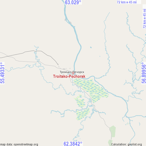
Troitsko-Pechorsk GPS coordinates[2]
62° 42' 30.096" North, 56° 11' 47.148" East
| Map corner | latitude | longitude |
|---|---|---|
| Upper-left | 63.029°, | 55.49331° |
| Center: | 62.70836°, | 56.19643° |
| Lower-right: | 62.3842°, | 56.89956° |
| Map W x H: | 71.7×71.7 km | = 44.6×44.6mi |
| max Lat: | 73.50819° ⇑4.1% North |
| Troitsko-Pechorsk: | 62.70836° |
| min Lat: | ⇓95.9% South 41.28413° |
| min Long | Troitsko-Pechor | max Long |
| -179.12198° | 56.19643° | 179.35046° |
| W 67.8%⇐ | ⇒32.2% E |
Elevation
Elevation of Troitsko-Pechorsk is 100 m = 328 ft, and this is 102.6 m = 337 ft below average elevation for this country.
| Max E: |
2518 m = 8261 ft | 71% |
| Avg. | 202.6 m = 665 ft | |
| Troitsko-Pechorsk | 100 m = 328 ft | |
Min E: |
-28 m = -92 ft | 29% |
See also: Russia elevation on elevation.city.
Geographical zone
Troitsko-Pechorsk is located in North temperate zone (between Tropic of Cancer and the Arctic Circle). Distance of this North polar circle is 428.7 km =266.4 mi to North.| Distance of | km | miles | from Troitsko-Pechorsk |
|---|---|---|---|
| North Pole | 3034.5 | 1885.6 | to North |
| Arctic Circle | 428.7 | 266.4 | to North |
| Tropic Cancer | 4366.6 | 2713.3 | to South |
| Equator | 6972.5 | 4332.5 | to South |


Nearby cities:
15 places around Troitsko-Pechorsk: (largest is in red/bold)
• Borovoy
176.8 km =109.9 mi,  289°
289°
• Cherdyn’
256.8 km =159.6 mi,  176°
176°
• Kozhva
269.9 km =167.7 mi,  8°
8°
• Krasnovishersk
260.1 km =161.6 mi,  169°
169°
• Nizhniy Odes
123.9 km =77 mi,  327°
327°
• Nyrob
221.4 km =137.6 mi, 172°
• Pechora
275.8 km =171.4 mi, 10°
• Shudayag
158.9 km =98.7 mi,  304°
304°
• Sosnogorsk
152.9 km =95 mi,  310°
310°
• Ukhta
158.3 km =98.4 mi, 307°
• Ust’-Kulom
172.6 km =107.2 mi,  228°
228°
• Vodnyy
165.8 km =103 mi, 302°
• Voyvozh
65.9 km =40.9 mi, 288°
• Vuktyl
139.3 km =86.6 mi,  23°
23°
• Yarega
154.7 km =96.1 mi, 301°
Sources, notices
• [Note1] Compared only with cities in Russia existing in our database
• [Src1] Map data: © OpenStreetMap contributors (CC-BY-SA)
• [Src2] Other city data from geonames.org with taken over terms of usage.
• [Src3] Geographical zone / Annual Mean Temperature by Robert A. Rohde @ Wikipedia
