Tikhoretsk geodata
Tikhoretsk (Krasnodarskiy) is a seat of a second-order administrative division; located in Russia in Europe/Moscow (GMT+3) time zone. With population of 64,387 people, there are 317 cities with bigger population in this country. Compared to other cities in Russia, 84.5% of cities are located further ↑North; 66.9% of cities are located further →East and 76.9% of cities have higher elevation than Tikhoretsk. Note1


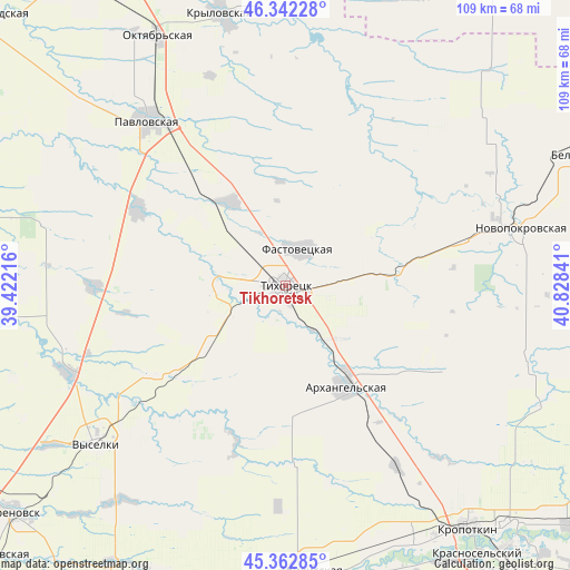
Tikhoretsk GPS coordinates[2]
45° 51' 16.992" North, 40° 7' 31.008" East
| Map corner | latitude | longitude |
|---|---|---|
| Upper-left | 46.34228°, | 39.42216° |
| Center: | 45.85472°, | 40.12528° |
| Lower-right: | 45.36285°, | 40.82841° |
| Map W x H: | 108.9×108.9 km | = 67.7×67.7mi |
| max Lat: | 73.50819° ⇑84.5% North |
| Tikhoretsk: | 45.85472° |
| min Lat: | ⇓15.5% South 41.28413° |
| min Long | Tikhoretsk | max Long |
| -179.12198° | 40.12528° | 179.35046° |
| W 33.1%⇐ | ⇒66.9% E |
Elevation
Elevation of Tikhoretsk is 81 m = 266 ft, and this is 121.6 m = 399 ft below average elevation for this country.
| Max E: |
2518 m = 8261 ft | 76.9% |
| Avg. | 202.6 m = 665 ft | |
| Tikhoretsk | 81 m = 266 ft | |
Min E: |
-28 m = -92 ft | 23.1% |
See also: Tikhoretsk elevation on elevation.city.
Geographical zone
Tikhoretsk is located in North temperate zone (between Tropic of Cancer and the Arctic Circle). Distance of this North polar circle is 2302.6 km =1430.8 mi to North.| Distance of | km | miles | from Tikhoretsk |
|---|---|---|---|
| North Pole | 4908.5 | 3050 | to North |
| Arctic Circle | 2302.6 | 1430.8 | to North |
| Tropic Cancer | 2492.6 | 1548.8 | to South |
| Equator | 5098.6 | 3168.1 | to South |


Nearby cities:
15 places around Tikhoretsk: (largest is in red/bold)
• Alekseyevskaya
9.5 km =5.9 mi,  165°
165°
• Fastovetskaya
7.6 km =4.7 mi,  20°
20°
• Irkliyevskaya
36.5 km =22.7 mi,  270°
270°
• Kalnibolotskaya
30.7 km =19.1 mi,  56°
56°
• Kubanskiy
36.2 km =22.5 mi,  76°
76°
• Lenina
35.4 km =22 mi,  311°
311°
• Lovlinskaya
38.7 km =24 mi, 166°
• Mirskoy
40.6 km =25.2 mi,  148°
148°
• Novoleushkovskaya
18.7 km =11.6 mi,  326°
326°
• Novomalorossiyskaya
30.3 km =18.8 mi,  216°
216°
• Novorozhdestvenskaya
13.6 km =8.5 mi, 272°
• Parkovyy
2.9 km =1.8 mi, 146°
• Pavlovskaya
41.1 km =25.5 mi,  319°
319°
• Staroleushkovskaya
31.8 km =19.8 mi,  297°
297°
• Ternevskaya
22.2 km =13.8 mi,  90°
90°
In other languages:
- In Spanish: Tijoretsk
- In Italian: Tichoreck
- In Russian: Тихорецк
- In Chinese: 季霍列茨克
Sources, notices
• [Note1] Compared only with cities in Russia existing in our database
• [Src1] Map data: © OpenStreetMap contributors (CC-BY-SA)
• [Src2] Other city data from geonames.org with taken over terms of usage.
• [Src3] Geographical zone / Annual Mean Temperature by Robert A. Rohde @ Wikipedia
