Batyrevo geodata
Batyrevo (Chuvashia) is a populated place; located in Russia in Europe/Moscow (GMT+3) time zone. With population of 5,648 people, there are 2380 cities with bigger population in this country. Compared to other cities in Russia, 54.2% of cities are located further ↓South; 57.8% of cities are located further ←West and 70.2% of cities have higher elevation than Batyrevo. Note1


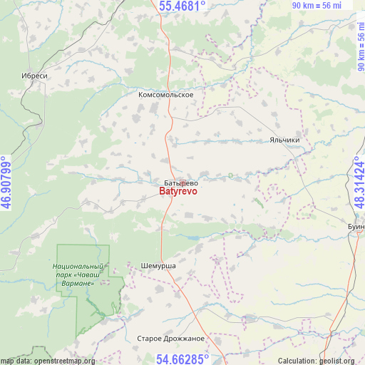
Batyrevo GPS coordinates[2]
55° 4' 3" North, 47° 36' 39.996" East
| Map corner | latitude | longitude |
|---|---|---|
| Upper-left | 55.4681°, | 46.90799° |
| Center: | 55.0675°, | 47.61111° |
| Lower-right: | 54.66285°, | 48.31424° |
| Map W x H: | 89.5×89.5 km | = 55.6×55.6mi |
| max Lat: | 73.50819° ⇑45.8% North |
| Batyrevo: | 55.0675° |
| min Lat: | ⇓54.2% South 41.28413° |
| min Long | Batyrevo | max Long |
| -179.12198° | 47.61111° | 179.35046° |
| W 57.8%⇐ | ⇒42.2% E |
Elevation
Elevation of Batyrevo is 102 m = 335 ft, and this is 100.6 m = 330 ft below average elevation for this country.
| Max E: |
2518 m = 8261 ft | 70.2% |
| Avg. | 202.6 m = 665 ft | |
| Batyrevo | 102 m = 335 ft | |
Min E: |
-28 m = -92 ft | 29.8% |
See also: Russia elevation on elevation.city.
Geographical zone
Batyrevo is located in North temperate zone (between Tropic of Cancer and the Arctic Circle). Distance of this North polar circle is 1278.2 km =794.2 mi to North.| Distance of | km | miles | from Batyrevo |
|---|---|---|---|
| North Pole | 3884.1 | 2413.5 | to North |
| Arctic Circle | 1278.2 | 794.2 | to North |
| Tropic Cancer | 3517 | 2185.4 | to South |
| Equator | 6122.9 | 3804.6 | to South |


Nearby cities:
15 places around Batyrevo: (largest is in red/bold)
• Alatyr’
70.4 km =43.7 mi,  249°
249°
• Apastovo
59.1 km =36.7 mi,  75°
75°
• Buinsk
37.7 km =23.4 mi,  292°
292°
• Buinsk
44.7 km =27.8 mi,  103°
103°
• Ibresi
44.7 km =27.8 mi,  305°
305°
• Kanash
49.7 km =30.9 mi,  351°
351°
• Kirya
47.8 km =29.7 mi,  271°
271°
• Komsomol'skoye
21.4 km =13.3 mi, 348°
• Shemursha
21 km =13 mi,  196°
196°
• Shikhazany
56.5 km =35.1 mi, 345°
• Staroye Drozhzhanoye
38 km =23.6 mi,  184°
184°
• Tsil’na
62.5 km =38.8 mi,  147°
147°
• Undory
71.5 km =44.4 mi,  135°
135°
• Urmary
71.2 km =44.2 mi,  17°
17°
• Vurnary
62.3 km =38.7 mi,  318°
318°
Sources, notices
• [Note1] Compared only with cities in Russia existing in our database
• [Src1] Map data: © OpenStreetMap contributors (CC-BY-SA)
• [Src2] Other city data from geonames.org with taken over terms of usage.
• [Src3] Geographical zone / Annual Mean Temperature by Robert A. Rohde @ Wikipedia
