Terek geodata
Terek (Kabardino-Balkariya Republic) is a populated place; located in Russia in Europe/Moscow (GMT+3) time zone. With population of 21,180 people, there are 832 cities with bigger population in this country. Compared to other cities in Russia, 94.2% of cities are located further ↑North; 52.5% of cities are located further →East and 81.1% of cities have lower elevation than Terek. Note1


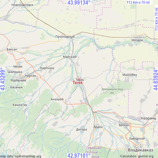
Terek GPS coordinates[2]
43° 28' 59.988" North, 44° 8' 9.996" East
| Map corner | latitude | longitude |
|---|---|---|
| Upper-left | 43.99134°, | 43.43299° |
| Center: | 43.48333°, | 44.13611° |
| Lower-right: | 42.97101°, | 44.83924° |
| Map W x H: | 113.5×113.4 km | = 70.5×70.5mi |
| max Lat: | 73.50819° ⇑94.2% North |
| Terek: | 43.48333° |
| min Lat: | ⇓5.8% South 41.28413° |
| min Long | Terek | max Long |
| -179.12198° | 44.13611° | 179.35046° |
| W 47.5%⇐ | ⇒52.5% E |
Elevation
Elevation of Terek is 260 m = 853 ft, and this is 57.4 m = 188 ft above average elevation for this country.
| Max E: |
2518 m = 8261 ft | 18.9% |
| Terek | 260 m 853 ft | |
| Avg. | 202.6 m = 665 ft | |
Min E: |
-28 m = -92 ft | 81.1% |
See also: Russia elevation on elevation.city.
Geographical zone
Terek is located in North temperate zone (between Tropic of Cancer and the Arctic Circle). Distance of this Northern Tropic circle is 2229 km =1385 mi to South.| Distance of | km | miles | from Terek |
|---|---|---|---|
| North Pole | 5172.2 | 3213.9 | to North |
| Arctic Circle | 2566.3 | 1594.6 | to North |
| Tropic Cancer | 2229 | 1385 | to South |
| Equator | 4834.9 | 3004.3 | to South |


Nearby cities:
15 places around Terek: (largest is in red/bold)
• Argudan
19.1 km =11.9 mi,  248°
248°
• Deyskoye
2.3 km =1.4 mi,  112°
112°
• Kakhun
22 km =13.7 mi,  287°
287°
• Kardzhin
26.4 km =16.4 mi,  151°
151°
• Kotlyarevskaya
11.7 km =7.3 mi,  328°
328°
• Mayskiy
19.3 km =12 mi,  335°
335°
• Nartkala
24.4 km =15.2 mi, 289°
• Nizhniy Cherek
18.2 km =11.3 mi,  280°
280°
• Planovskoye
10.6 km =6.6 mi, 153°
• Psygansu
28.5 km =17.7 mi,  255°
255°
• Staryy Cherek
23.4 km =14.5 mi,  266°
266°
• Staryy Urukh
18.5 km =11.5 mi,  210°
210°
• Urukh
22.9 km =14.2 mi,  202°
202°
• Urvan’
30.3 km =18.8 mi, 271°
• Zmeyskaya
16.5 km =10.3 mi,  174°
174°
Sources, notices
• [Note1] Compared only with cities in Russia existing in our database
• [Src1] Map data: © OpenStreetMap contributors (CC-BY-SA)
• [Src2] Other city data from geonames.org with taken over terms of usage.
• [Src3] Geographical zone / Annual Mean Temperature by Robert A. Rohde @ Wikipedia
