Kotlyarevskaya geodata
Kotlyarevskaya (Kabardino-Balkariya Republic) is a populated place; located in Russia in Europe/Moscow (GMT+3) time zone. With population of 3,887 people, there are 3178 cities with bigger population in this country. Compared to other cities in Russia, 93.6% of cities are located further ↑North; 52.7% of cities are located further →East and 77.3% of cities have lower elevation than Kotlyarevskaya. Note1


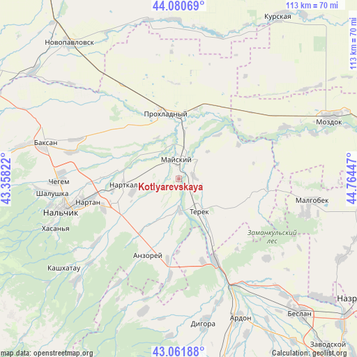
Kotlyarevskaya GPS coordinates[2]
43° 34' 24.384" North, 44° 3' 40.824" East
| Map corner | latitude | longitude |
|---|---|---|
| Upper-left | 44.08069°, | 43.35822° |
| Center: | 43.57344°, | 44.06134° |
| Lower-right: | 43.06188°, | 44.76447° |
| Map W x H: | 113.3×113.3 km | = 70.4×70.4mi |
| max Lat: | 73.50819° ⇑93.6% North |
| Kotlyarevskaya: | 43.57344° |
| min Lat: | ⇓6.4% South 41.28413° |
| min Long | Kotlyarevskaya | max Long |
| -179.12198° | 44.06134° | 179.35046° |
| W 47.3%⇐ | ⇒52.7% E |
Elevation
Elevation of Kotlyarevskaya is 228 m = 748 ft, and this is 25.4 m = 83 ft above average elevation for this country.
| Max E: |
2518 m = 8261 ft | 22.7% |
| Kotlyarevskaya | 228 m 748 ft | |
| Avg. | 202.6 m = 665 ft | |
Min E: |
-28 m = -92 ft | 77.3% |
See also: Russia elevation on elevation.city.
Geographical zone
Kotlyarevskaya is located in North temperate zone (between Tropic of Cancer and the Arctic Circle). Distance of this Northern Tropic circle is 2239 km =1391.2 mi to South.| Distance of | km | miles | from Kotlyarevskaya |
|---|---|---|---|
| North Pole | 5162.1 | 3207.6 | to North |
| Arctic Circle | 2556.3 | 1588.4 | to North |
| Tropic Cancer | 2239 | 1391.2 | to South |
| Equator | 4844.9 | 3010.5 | to South |


Nearby cities:
15 places around Kotlyarevskaya: (largest is in red/bold)
• Altud
22.8 km =14.2 mi,  316°
316°
• Argudan
20.6 km =12.8 mi,  214°
214°
• Deyskoye
13.6 km =8.5 mi,  143°
143°
• Germenchik
23.9 km =14.9 mi,  275°
275°
• Kakhun
15.3 km =9.5 mi,  257°
257°
• Mayskiy
7.8 km =4.8 mi,  346°
346°
• Nartkala
17.1 km =10.6 mi, 264°
• Nizhniy Cherek
13.6 km =8.5 mi,  240°
240°
• Planovskoye
22.2 km =13.8 mi,  151°
151°
• Primalkinskoye
19.7 km =12.2 mi, 347°
• Prokhladnyy
20.6 km =12.8 mi, 352°
• Staryy Cherek
20.7 km =12.9 mi, 236°
• Staryy Urukh
26.1 km =16.2 mi,  187°
187°
• Terek
11.7 km =7.3 mi, 148°
• Urvan’
25.9 km =16.1 mi,  249°
249°
Sources, notices
• [Note1] Compared only with cities in Russia existing in our database
• [Src1] Map data: © OpenStreetMap contributors (CC-BY-SA)
• [Src2] Other city data from geonames.org with taken over terms of usage.
• [Src3] Geographical zone / Annual Mean Temperature by Robert A. Rohde @ Wikipedia
