Tatarka geodata
Tatarka (Stavropol’ Kray) is a populated place; located in Russia in Europe/Moscow (GMT+3) time zone. With population of 6,062 people, there are 2237 cities with bigger population in this country. Compared to other cities in Russia, 87.5% of cities are located further ↑North; 59.9% of cities are located further →East and 90.3% of cities have lower elevation than Tatarka. Note1


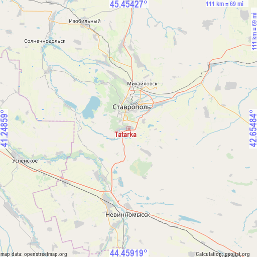
Tatarka GPS coordinates[2]
44° 57' 32.004" North, 41° 57' 6.156" East
| Map corner | latitude | longitude |
|---|---|---|
| Upper-left | 45.45427°, | 41.24859° |
| Center: | 44.95889°, | 41.95171° |
| Lower-right: | 44.45919°, | 42.65484° |
| Map W x H: | 110.6×110.6 km | = 68.7×68.7mi |
| max Lat: | 73.50819° ⇑87.5% North |
| Tatarka: | 44.95889° |
| min Lat: | ⇓12.5% South 41.28413° |
| min Long | Tatarka | max Long |
| -179.12198° | 41.95171° | 179.35046° |
| W 40.1%⇐ | ⇒59.9% E |
Elevation
Elevation of Tatarka is 459 m = 1506 ft, and this is 256.4 m = 841 ft above average elevation for this country.
| Max E: |
2518 m = 8261 ft | 9.7% |
| Tatarka | 459 m 1506 ft | |
| Avg. | 202.6 m = 665 ft | |
Min E: |
-28 m = -92 ft | 90.3% |
See also: Russia elevation on elevation.city.
Geographical zone
Tatarka is located in North temperate zone (between Tropic of Cancer and the Arctic Circle). Distance of this Northern Tropic circle is 2393 km =1486.9 mi to South.| Distance of | km | miles | from Tatarka |
|---|---|---|---|
| North Pole | 5008.1 | 3111.9 | to North |
| Arctic Circle | 2402.2 | 1492.7 | to North |
| Tropic Cancer | 2393 | 1486.9 | to South |
| Equator | 4999 | 3106.2 | to South |


Nearby cities:
15 places around Tatarka: (largest is in red/bold)
• Balakhonovskoye
24.2 km =15 mi,  213°
213°
• Barsukovskaya
24.1 km =15 mi, 205°
• Beshpagir
34.5 km =21.4 mi,  78°
78°
• Ivanovskoye
42.6 km =26.5 mi,  188°
188°
• Izobil’nyy
49.6 km =30.8 mi,  337°
337°
• Kochubeyevskoye
36 km =22.4 mi, 193°
• Mikhaylovsk
19.7 km =12.2 mi,  17°
17°
• Moskovskoye
36.3 km =22.6 mi,  354°
354°
• Nevinnomyssk
36.2 km =22.5 mi,  180°
180°
• Pelagiada
28.1 km =17.5 mi,  11°
11°
• Ryzdvyanyy
35.2 km =21.9 mi, 345°
• Spitsevka
47.7 km =29.6 mi,  67°
67°
• Stavropol’
9.5 km =5.9 mi, 10°
• Uspenskoye
46.3 km =28.8 mi,  252°
252°
• Zavetnoye
36.3 km =22.6 mi,  229°
229°
Sources, notices
• [Note1] Compared only with cities in Russia existing in our database
• [Src1] Map data: © OpenStreetMap contributors (CC-BY-SA)
• [Src2] Other city data from geonames.org with taken over terms of usage.
• [Src3] Geographical zone / Annual Mean Temperature by Robert A. Rohde @ Wikipedia
