Mikhaylovsk geodata
Mikhaylovsk (Stavropol’ Kray) is a populated place; located in Russia in Europe/Moscow (GMT+3) time zone. With population of 59,198 people, there are 355 cities with bigger population in this country. Compared to other cities in Russia, 86.7% of cities are located further ↑North; 59.6% of cities are located further →East and 88.9% of cities have lower elevation than Mikhaylovsk. Note1


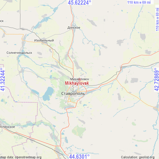
Mikhaylovsk GPS coordinates[2]
45° 7' 41.988" North, 42° 1' 32.016" East
| Map corner | latitude | longitude |
|---|---|---|
| Upper-left | 45.62224°, | 41.32244° |
| Center: | 45.12833°, | 42.02556° |
| Lower-right: | 44.6301°, | 42.72869° |
| Map W x H: | 110.3×110.3 km | = 68.5×68.5mi |
| max Lat: | 73.50819° ⇑86.7% North |
| Mikhaylovsk: | 45.12833° |
| min Lat: | ⇓13.3% South 41.28413° |
| min Long | Mikhaylovsk | max Long |
| -179.12198° | 42.02556° | 179.35046° |
| W 40.4%⇐ | ⇒59.6% E |
Elevation
Elevation of Mikhaylovsk is 425 m = 1394 ft, and this is 222.4 m = 730 ft above average elevation for this country.
| Max E: |
2518 m = 8261 ft | 11.1% |
| Mikhaylovsk | 425 m 1394 ft | |
| Avg. | 202.6 m = 665 ft | |
Min E: |
-28 m = -92 ft | 88.9% |
See also: Mikhaylovsk elevation on elevation.city.
Geographical zone
Mikhaylovsk is located in North temperate zone (between Tropic of Cancer and the Arctic Circle). Distance of this North polar circle is 2383.4 km =1481 mi to North.| Distance of | km | miles | from Mikhaylovsk |
|---|---|---|---|
| North Pole | 4989.3 | 3100.2 | to North |
| Arctic Circle | 2383.4 | 1481 | to North |
| Tropic Cancer | 2411.9 | 1498.7 | to South |
| Equator | 5017.8 | 3117.9 | to South |


Nearby cities:
15 places around Mikhaylovsk: (largest is in red/bold)
• Balakhonovskoye
43.5 km =27 mi,  205°
205°
• Barsukovskaya
43.7 km =27.2 mi,  201°
201°
• Beshpagir
30.3 km =18.8 mi,  113°
113°
• Donskoye
36.6 km =22.7 mi,  353°
353°
• Izobil’nyy
36.7 km =22.8 mi,  317°
317°
• Konstantinovskoye
51.5 km =32 mi,  68°
68°
• Moskovskoye
19.5 km =12.1 mi,  332°
332°
• Novotroitskaya
45 km =28 mi,  299°
299°
• Pelagiada
8.7 km =5.4 mi,  358°
358°
• Ryzdvyanyy
21.1 km =13.1 mi, 316°
• Spitsevka
38.2 km =23.7 mi,  90°
90°
• Stavropol’
10.4 km =6.5 mi, 203°
• Tatarka
19.7 km =12.2 mi, 197°
• Tishchenskoye
46.1 km =28.6 mi, 323°
• Trunovskoye
40.9 km =25.4 mi,  12°
12°
Sources, notices
• [Note1] Compared only with cities in Russia existing in our database
• [Src1] Map data: © OpenStreetMap contributors (CC-BY-SA)
• [Src2] Other city data from geonames.org with taken over terms of usage.
• [Src3] Geographical zone / Annual Mean Temperature by Robert A. Rohde @ Wikipedia
