Pelagiada geodata
Pelagiada (Stavropol’ Kray) is a populated place; located in Russia in Europe/Moscow (GMT+3) time zone. With population of 6,871 people, there are 2033 cities with bigger population in this country. Compared to other cities in Russia, 86.4% of cities are located further ↑North; 59.6% of cities are located further →East and 85.4% of cities have lower elevation than Pelagiada. Note1


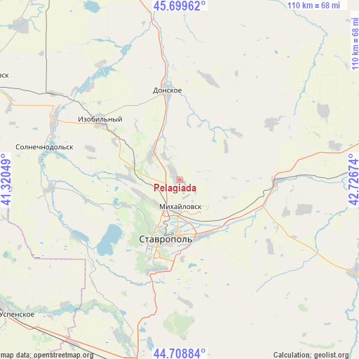
Pelagiada GPS coordinates[2]
45° 12' 23.004" North, 42° 1' 24.996" East
| Map corner | latitude | longitude |
|---|---|---|
| Upper-left | 45.69962°, | 41.32049° |
| Center: | 45.20639°, | 42.02361° |
| Lower-right: | 44.70884°, | 42.72674° |
| Map W x H: | 110.2×110.2 km | = 68.5×68.5mi |
| max Lat: | 73.50819° ⇑86.4% North |
| Pelagiada: | 45.20639° |
| min Lat: | ⇓13.6% South 41.28413° |
| min Long | Pelagiada | max Long |
| -179.12198° | 42.02361° | 179.35046° |
| W 40.4%⇐ | ⇒59.6% E |
Elevation
Elevation of Pelagiada is 330 m = 1083 ft, and this is 127.4 m = 418 ft above average elevation for this country.
| Max E: |
2518 m = 8261 ft | 14.6% |
| Pelagiada | 330 m 1083 ft | |
| Avg. | 202.6 m = 665 ft | |
Min E: |
-28 m = -92 ft | 85.4% |
See also: Russia elevation on elevation.city.
Geographical zone
Pelagiada is located in North temperate zone (between Tropic of Cancer and the Arctic Circle). Distance of this North polar circle is 2374.7 km =1475.6 mi to North.| Distance of | km | miles | from Pelagiada |
|---|---|---|---|
| North Pole | 4980.6 | 3094.8 | to North |
| Arctic Circle | 2374.7 | 1475.6 | to North |
| Tropic Cancer | 2420.6 | 1504.1 | to South |
| Equator | 5026.5 | 3123.3 | to South |


Nearby cities:
15 places around Pelagiada: (largest is in red/bold)
• Beshpagir
34.7 km =21.6 mi,  126°
126°
• Bezopasnoye
49.6 km =30.8 mi,  352°
352°
• Blagodatnoye
49 km =30.4 mi,  63°
63°
• Donskoye
27.9 km =17.3 mi, 352°
• Izobil’nyy
30.7 km =19.1 mi,  306°
306°
• Konstantinovskoye
49.1 km =30.5 mi,  77°
77°
• Mikhaylovsk
8.7 km =5.4 mi,  178°
178°
• Moskovskoye
12.4 km =7.7 mi, 314°
• Novotroitskaya
41.2 km =25.6 mi,  288°
288°
• Ryzdvyanyy
15.9 km =9.9 mi, 294°
• Spitsevka
39.4 km =24.5 mi,  103°
103°
• Stavropol’
18.6 km =11.6 mi,  192°
192°
• Tatarka
28.1 km =17.5 mi, 191°
• Tishchenskoye
39.3 km =24.4 mi,  315°
315°
• Trunovskoye
32.5 km =20.2 mi,  15°
15°
Sources, notices
• [Note1] Compared only with cities in Russia existing in our database
• [Src1] Map data: © OpenStreetMap contributors (CC-BY-SA)
• [Src2] Other city data from geonames.org with taken over terms of usage.
• [Src3] Geographical zone / Annual Mean Temperature by Robert A. Rohde @ Wikipedia
