Tambov geodata
Tambov is a seat of a first-order administrative division; located in Russia in Europe/Moscow (GMT+3) time zone. With population of 290,933 people, there are 67 cities with bigger population in this country. Compared to other cities in Russia, 64.5% of cities are located further ↑North; 61.6% of cities are located further →East and 58.2% of cities have higher elevation than Tambov. Note1


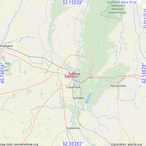
Tambov GPS coordinates[2]
52° 43' 54.084" North, 41° 26' 35.736" East
| Map corner | latitude | longitude |
|---|---|---|
| Upper-left | 53.15539°, | 40.74014° |
| Center: | 52.73169°, | 41.44326° |
| Lower-right: | 52.30383°, | 42.14639° |
| Map W x H: | 94.7×94.7 km | = 58.8×58.8mi |
| max Lat: | 73.50819° ⇑64.5% North |
| Tambov: | 52.73169° |
| min Lat: | ⇓35.5% South 41.28413° |
| min Long | Tambov | max Long |
| -179.12198° | 41.44326° | 179.35046° |
| W 38.4%⇐ | ⇒61.6% E |
Elevation
Elevation of Tambov is 128 m = 420 ft, and this is 74.6 m = 245 ft below average elevation for this country.
| Max E: |
2518 m = 8261 ft | 58.2% |
| Avg. | 202.6 m = 665 ft | |
| Tambov | 128 m = 420 ft | |
Min E: |
-28 m = -92 ft | 41.8% |
See also: Tambov elevation on elevation.city.
Geographical zone
Tambov is located in North temperate zone (between Tropic of Cancer and the Arctic Circle). Distance of this North polar circle is 1538 km =955.7 mi to North.| Distance of | km | miles | from Tambov |
|---|---|---|---|
| North Pole | 4143.8 | 2574.8 | to North |
| Arctic Circle | 1538 | 955.7 | to North |
| Tropic Cancer | 3257.3 | 2024 | to South |
| Equator | 5863.2 | 3643.2 | to South |


Nearby cities:
15 places around Tambov: (largest is in red/bold)
• Bokino
10.5 km =6.5 mi,  173°
173°
• Donskoye
5.3 km =3.3 mi,  25°
25°
• Goreloye
23.2 km =14.4 mi,  10°
10°
• Komsomolets
11.3 km =7 mi,  291°
291°
• Kotovsk
16.6 km =10.3 mi, 166°
• Michurinsk
66.6 km =41.4 mi, 286°
• Novaya Lyada
13.3 km =8.3 mi,  98°
98°
• Platonovka
34.3 km =21.3 mi,  93°
93°
• Pokrovo-Prigorodnoye
5.6 km =3.5 mi,  198°
198°
• Rasskazovo
30.9 km =19.2 mi,  105°
105°
• Satinka
42.4 km =26.3 mi,  157°
157°
• Selezni
15.9 km =9.9 mi,  300°
300°
• Sosnovka
56.3 km =35 mi,  354°
354°
• Zavoronezhskoye
62.1 km =38.6 mi, 285°
• Znamenka
35 km =21.7 mi,  181°
181°
Sources, notices
• [Note1] Compared only with cities in Russia existing in our database
• [Src1] Map data: © OpenStreetMap contributors (CC-BY-SA)
• [Src2] Other city data from geonames.org with taken over terms of usage.
• [Src3] Geographical zone / Annual Mean Temperature by Robert A. Rohde @ Wikipedia
