Sterlibashevo geodata
Sterlibashevo (Bashkortostan Republic) is a populated place; located in Russia in Asia/Yekaterinburg (GMT+5) time zone. With population of 5,786 people, there are 2336 cities with bigger population in this country. Compared to other cities in Russia, 59.2% of cities are located further ↑North; 66.7% of cities are located further ←West and 80.7% of cities have lower elevation than Sterlibashevo. Note1


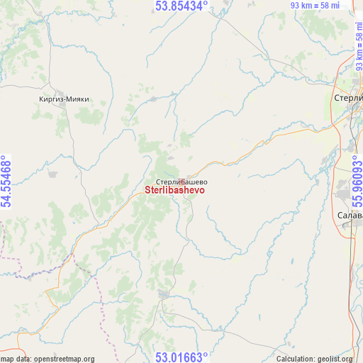
Sterlibashevo GPS coordinates[2]
53° 26' 15.18" North, 55° 15' 28.08" East
| Map corner | latitude | longitude |
|---|---|---|
| Upper-left | 53.85434°, | 54.55468° |
| Center: | 53.43755°, | 55.2578° |
| Lower-right: | 53.01663°, | 55.96093° |
| Map W x H: | 93.1×93.1 km | = 57.8×57.8mi |
| max Lat: | 73.50819° ⇑59.2% North |
| Sterlibashevo: | 53.43755° |
| min Lat: | ⇓40.8% South 41.28413° |
| min Long | Sterlibashevo | max Long |
| -179.12198° | 55.2578° | 179.35046° |
| W 66.7%⇐ | ⇒33.3% E |
Elevation
Elevation of Sterlibashevo is 254 m = 833 ft, and this is 51.4 m = 169 ft above average elevation for this country.
| Max E: |
2518 m = 8261 ft | 19.3% |
| Sterlibashevo | 254 m 833 ft | |
| Avg. | 202.6 m = 665 ft | |
Min E: |
-28 m = -92 ft | 80.7% |
See also: Russia elevation on elevation.city.
Geographical zone
Sterlibashevo is located in North temperate zone (between Tropic of Cancer and the Arctic Circle). Distance of this North polar circle is 1459.5 km =906.9 mi to North.| Distance of | km | miles | from Sterlibashevo |
|---|---|---|---|
| North Pole | 4065.4 | 2526.1 | to North |
| Arctic Circle | 1459.5 | 906.9 | to North |
| Tropic Cancer | 3335.8 | 2072.8 | to South |
| Equator | 5941.7 | 3692 | to South |


Nearby cities:
15 places around Sterlibashevo: (largest is in red/bold)
• Bizhbulyak
71.7 km =44.6 mi,  293°
293°
• Ishimbay
51.9 km =32.2 mi,  87°
87°
• Kirgiz-Miyaki
37.3 km =23.2 mi,  305°
305°
• Kumertau
82.4 km =51.2 mi,  154°
154°
• Mayskiy
27.8 km =17.3 mi,  27°
27°
• Meleuz
69.2 km =43 mi,  139°
139°
• Rayevskiy
72.8 km =45.2 mi,  343°
343°
• Salavat
43.5 km =27 mi,  97°
97°
• Shafranovo
67.1 km =41.7 mi,  331°
331°
• Sharlyk
67.1 km =41.7 mi,  210°
210°
• Sterlitamak
50.3 km =31.3 mi,  65°
65°
• Tolbazy
77.1 km =47.9 mi, 32°
• Voskresenskoye
68.6 km =42.6 mi,  120°
120°
• Yermolayevo
88 km =54.7 mi,  155°
155°
• Zirgan
50 km =31.1 mi, 118°
Sources, notices
• [Note1] Compared only with cities in Russia existing in our database
• [Src1] Map data: © OpenStreetMap contributors (CC-BY-SA)
• [Src2] Other city data from geonames.org with taken over terms of usage.
• [Src3] Geographical zone / Annual Mean Temperature by Robert A. Rohde @ Wikipedia
