Kumertau geodata
Kumertau (Bashkortostan Republic) is a populated place; located in Russia in Asia/Yekaterinburg (GMT+5) time zone. With population of 65,321 people, there are 315 cities with bigger population in this country. Compared to other cities in Russia, 64.3% of cities are located further ↑North; 67.1% of cities are located further ←West and 83% of cities have lower elevation than Kumertau. Note1


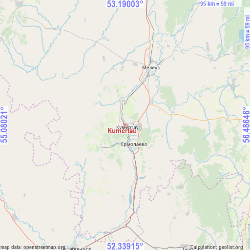
Kumertau GPS coordinates[2]
52° 46' 0.012" North, 55° 46' 59.988" East
| Map corner | latitude | longitude |
|---|---|---|
| Upper-left | 53.19003°, | 55.08021° |
| Center: | 52.76667°, | 55.78333° |
| Lower-right: | 52.33915°, | 56.48646° |
| Map W x H: | 94.6×94.6 km | = 58.8×58.8mi |
| max Lat: | 73.50819° ⇑64.3% North |
| Kumertau: | 52.76667° |
| min Lat: | ⇓35.7% South 41.28413° |
| min Long | Kumertau | max Long |
| -179.12198° | 55.78333° | 179.35046° |
| W 67.1%⇐ | ⇒32.9% E |
Elevation
Elevation of Kumertau is 285 m = 935 ft, and this is 82.4 m = 270 ft above average elevation for this country.
| Max E: |
2518 m = 8261 ft | 17% |
| Kumertau | 285 m 935 ft | |
| Avg. | 202.6 m = 665 ft | |
Min E: |
-28 m = -92 ft | 83% |
See also: Kumertau elevation on elevation.city.
Geographical zone
Kumertau is located in North temperate zone (between Tropic of Cancer and the Arctic Circle). Distance of this North polar circle is 1534.1 km =953.2 mi to North.| Distance of | km | miles | from Kumertau |
|---|---|---|---|
| North Pole | 4140 | 2572.5 | to North |
| Arctic Circle | 1534.1 | 953.2 | to North |
| Tropic Cancer | 3261.2 | 2026.4 | to South |
| Equator | 5867.1 | 3645.6 | to South |


Nearby cities:
15 places around Kumertau: (largest is in red/bold)
• Ishimbay
78.4 km =48.7 mi,  12°
12°
• Isyangulovo
84.2 km =52.3 mi,  140°
140°
• Matveyevka
73.7 km =45.8 mi,  158°
158°
• Mayachnyy
11.3 km =7 mi,  215°
215°
• Meleuz
24.2 km =15 mi,  24°
24°
• Mrakovo
56.9 km =35.4 mi,  95°
95°
• Sakmara
92.2 km =57.3 mi,  199°
199°
• Salavat
69.1 km =42.9 mi, 6°
• Sharlyk
71.4 km =44.4 mi,  283°
283°
• Sterlibashevo
82.4 km =51.2 mi,  334°
334°
• Tyul’gan
54 km =33.6 mi,  151°
151°
• Voskresenskoye
46.5 km =28.9 mi,  31°
31°
• Yermolayevo
5.7 km =3.5 mi,  168°
168°
• Yumaguzino
43.7 km =27.2 mi,  69°
69°
• Zirgan
51.5 km =32 mi, 10°
Sources, notices
• [Note1] Compared only with cities in Russia existing in our database
• [Src1] Map data: © OpenStreetMap contributors (CC-BY-SA)
• [Src2] Other city data from geonames.org with taken over terms of usage.
• [Src3] Geographical zone / Annual Mean Temperature by Robert A. Rohde @ Wikipedia
