Sharlyk geodata
Sharlyk (Orenburg Oblast) is a populated place; located in Russia in Asia/Yekaterinburg (GMT+5) time zone. With population of 8,072 people, there are 1787 cities with bigger population in this country. Compared to other cities in Russia, 63.3% of cities are located further ↑North; 66.2% of cities are located further ←West and 58.8% of cities have lower elevation than Sharlyk. Note1


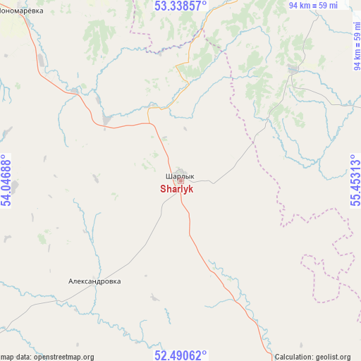
Sharlyk GPS coordinates[2]
52° 55' 0.012" North, 54° 45' 0" East
| Map corner | latitude | longitude |
|---|---|---|
| Upper-left | 53.33857°, | 54.04688° |
| Center: | 52.91667°, | 54.75° |
| Lower-right: | 52.49062°, | 55.45313° |
| Map W x H: | 94.3×94.3 km | = 58.6×58.6mi |
| max Lat: | 73.50819° ⇑63.3% North |
| Sharlyk: | 52.91667° |
| min Lat: | ⇓36.7% South 41.28413° |
| min Long | Sharlyk | max Long |
| -179.12198° | 54.75° | 179.35046° |
| W 66.2%⇐ | ⇒33.8% E |
Elevation
Elevation of Sharlyk is 165 m = 541 ft, and this is 37.6 m = 123 ft below average elevation for this country.
| Max E: |
2518 m = 8261 ft | 41.2% |
| Avg. | 202.6 m = 665 ft | |
| Sharlyk | 165 m = 541 ft | |
Min E: |
-28 m = -92 ft | 58.8% |
See also: Russia elevation on elevation.city.
Geographical zone
Sharlyk is located in North temperate zone (between Tropic of Cancer and the Arctic Circle). Distance of this North polar circle is 1517.4 km =942.9 mi to North.| Distance of | km | miles | from Sharlyk |
|---|---|---|---|
| North Pole | 4123.3 | 2562.1 | to North |
| Arctic Circle | 1517.4 | 942.9 | to North |
| Tropic Cancer | 3277.9 | 2036.8 | to South |
| Equator | 5883.8 | 3656 | to South |


Nearby cities:
15 places around Sharlyk: (largest is in red/bold)
• Bizhbulyak
92.5 km =57.5 mi,  339°
339°
• Ishimbay
104.8 km =65.1 mi,  55°
55°
• Kirgiz-Miyaki
79.6 km =49.5 mi,  2°
2°
• Kumertau
71.4 km =44.4 mi,  103°
103°
• Mayachnyy
68 km =42.3 mi,  112°
112°
• Mayskiy
94.9 km =59 mi,  29°
29°
• Meleuz
79.4 km =49.3 mi,  86°
86°
• Pleshanovo
85.5 km =53.1 mi,  263°
263°
• Sakmara
111 km =69 mi,  159°
159°
• Salavat
93 km =57.8 mi, 56°
• Sterlibashevo
67.1 km =41.7 mi, 30°
• Voskresenskoye
96.2 km =59.8 mi,  76°
76°
• Yermolayevo
74 km =46 mi, 107°
• Yumaguzino
110.2 km =68.5 mi, 90°
• Zirgan
85.1 km =52.9 mi,  66°
66°
Sources, notices
• [Note1] Compared only with cities in Russia existing in our database
• [Src1] Map data: © OpenStreetMap contributors (CC-BY-SA)
• [Src2] Other city data from geonames.org with taken over terms of usage.
• [Src3] Geographical zone / Annual Mean Temperature by Robert A. Rohde @ Wikipedia
