Staraya Terizmorga geodata
Staraya Terizmorga (Mordoviya Republic) is a populated place; located in Russia in Europe/Moscow (GMT+3) time zone. With population of 955 people, there are 4678 cities with bigger population in this country. Compared to other cities in Russia, 53% of cities are located further ↑North; 51.5% of cities are located further →East and 54.9% of cities have lower elevation than Staraya Terizmorga. Note1


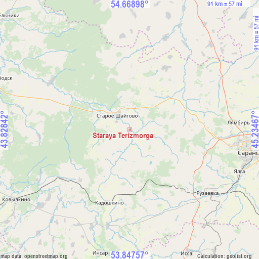
Staraya Terizmorga GPS coordinates[2]
54° 15' 37.152" North, 44° 31' 53.544" East
| Map corner | latitude | longitude |
|---|---|---|
| Upper-left | 54.66898°, | 43.82842° |
| Center: | 54.26032°, | 44.53154° |
| Lower-right: | 53.84757°, | 45.23467° |
| Map W x H: | 91.3×91.3 km | = 56.7×56.7mi |
| max Lat: | 73.50819° ⇑53% North |
| Staraya Terizmorga: | 54.26032° |
| min Lat: | ⇓47% South 41.28413° |
| min Long | Staraya Terizmo | max Long |
| -179.12198° | 44.53154° | 179.35046° |
| W 48.5%⇐ | ⇒51.5% E |
Elevation
Elevation of Staraya Terizmorga is 156 m = 512 ft, and this is 46.6 m = 153 ft below average elevation for this country.
| Max E: |
2518 m = 8261 ft | 45.1% |
| Avg. | 202.6 m = 665 ft | |
| Staraya Terizmorga | 156 m = 512 ft | |
Min E: |
-28 m = -92 ft | 54.9% |
See also: Russia elevation on elevation.city.
Geographical zone
Staraya Terizmorga is located in North temperate zone (between Tropic of Cancer and the Arctic Circle). Distance of this North polar circle is 1368 km =850 mi to North.| Distance of | km | miles | from Staraya Terizmorga |
|---|---|---|---|
| North Pole | 3973.9 | 2469.3 | to North |
| Arctic Circle | 1368 | 850 | to North |
| Tropic Cancer | 3427.3 | 2129.6 | to South |
| Equator | 6033.2 | 3748.9 | to South |


Nearby cities:
15 places around Staraya Terizmorga: (largest is in red/bold)
• Atemar
57.7 km =35.9 mi,  98°
98°
• Insar
45.1 km =28 mi,  193°
193°
• Issa
48.3 km =30 mi,  153°
153°
• Kadoshkino
27.1 km =16.8 mi,  195°
195°
• Kovylkino
47.2 km =29.3 mi,  238°
238°
• Krasnoslobodsk
51.5 km =32 mi,  290°
290°
• Lukhovka
48.8 km =30.3 mi, 104°
• Lyambir’
38.6 km =24 mi,  86°
86°
• Nikolayevka
41.9 km =26 mi,  107°
107°
• Pochinki
53.3 km =33.1 mi,  23°
23°
• Romodanovo
55 km =34.2 mi,  70°
70°
• Ruzayevka
35 km =21.7 mi,  128°
128°
• Saransk
42.7 km =26.5 mi, 101°
• Tatarskaya Pishlya
32.7 km =20.3 mi, 132°
• Zykovo
41.9 km =26 mi,  120°
120°
Sources, notices
• [Note1] Compared only with cities in Russia existing in our database
• [Src1] Map data: © OpenStreetMap contributors (CC-BY-SA)
• [Src2] Other city data from geonames.org with taken over terms of usage.
• [Src3] Geographical zone / Annual Mean Temperature by Robert A. Rohde @ Wikipedia
