Saransk geodata
Saransk (Mordoviya Republic) is a seat of a first-order administrative division; located in Russia in Europe/Moscow (GMT+3) time zone. With population of 303,394 people, there are 65 cities with bigger population in this country. Compared to other cities in Russia, 53.6% of cities are located further ↑North; 50.6% of cities are located further ←West and 61.6% of cities have lower elevation than Saransk. Note1


Saransk GPS coordinates[2]
54° 11' 1.68" North, 45° 10' 29.64" East
| Map corner | latitude | longitude |
|---|---|---|
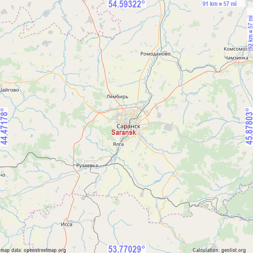
| Upper-left | 54.59322°, | 44.47178° |
| Center: | 54.1838°, | 45.1749° |
| Lower-right: | 53.77029°, | 45.87803° |
| Map W x H: | 91.5×91.5 km | = 56.9×56.9mi |
| max Lat: | 73.50819° ⇑53.6% North |
| Saransk: | 54.1838° |
| min Lat: | ⇓46.4% South 41.28413° |
| min Long | Saransk | max Long |
| -179.12198° | 45.1749° | 179.35046° |
| W 50.6%⇐ | ⇒49.4% E |
Elevation
Elevation of Saransk is 173 m = 568 ft, and this is 29.6 m = 97 ft below average elevation for this country.
| Max E: |
2518 m = 8261 ft | 38.4% |
| Avg. | 202.6 m = 665 ft | |
| Saransk | 173 m = 568 ft | |
Min E: |
-28 m = -92 ft | 61.6% |
See also: Saransk elevation on elevation.city.
Geographical zone
Saransk is located in North temperate zone (between Tropic of Cancer and the Arctic Circle). Distance of this North polar circle is 1376.5 km =855.3 mi to North.| Distance of | km | miles | from Saransk |
|---|---|---|---|
| North Pole | 3982.4 | 2474.5 | to North |
| Arctic Circle | 1376.5 | 855.3 | to North |
| Tropic Cancer | 3418.8 | 2124.3 | to South |
| Equator | 6024.7 | 3743.6 | to South |


Nearby cities:
15 places around Saransk: (largest is in red/bold)
• Atemar
15.2 km =9.4 mi,  91°
91°
• Chamzinka
46.4 km =28.8 mi,  58°
58°
• Issa
40.5 km =25.2 mi,  210°
210°
• Kadoshkino
52.3 km =32.5 mi,  250°
250°
• Kemlya
57.2 km =35.5 mi,  4°
4°
• Kochkurovo
22.9 km =14.2 mi,  136°
136°
• Lukhovka
6.6 km =4.1 mi,  126°
126°
• Lyambir’
11.4 km =7.1 mi,  343°
343°
• Nikolayevka
4.7 km =2.9 mi,  204°
204°
• Romodanovo
28.9 km =18 mi,  20°
20°
• Ruzayevka
19.8 km =12.3 mi,  227°
227°
• Staraya Terizmorga
42.7 km =26.5 mi,  281°
281°
• Sura
49.5 km =30.8 mi, 131°
• Tatarskaya Pishlya
22.5 km =14 mi, 232°
• Zykovo
14.1 km =8.8 mi, 204°
Sources, notices
• [Note1] Compared only with cities in Russia existing in our database
• [Src1] Map data: © OpenStreetMap contributors (CC-BY-SA)
• [Src2] Other city data from geonames.org with taken over terms of usage.
• [Src3] Geographical zone / Annual Mean Temperature by Robert A. Rohde @ Wikipedia
