Sovetskaya geodata
Sovetskaya (Krasnodarskiy) is a populated place; located in Russia in Europe/Moscow (GMT+3) time zone. With population of 10,166 people, there are 1486 cities with bigger population in this country. Compared to other cities in Russia, 88.4% of cities are located further ↑North; 62.4% of cities are located further →East and 83.1% of cities have lower elevation than Sovetskaya. Note1


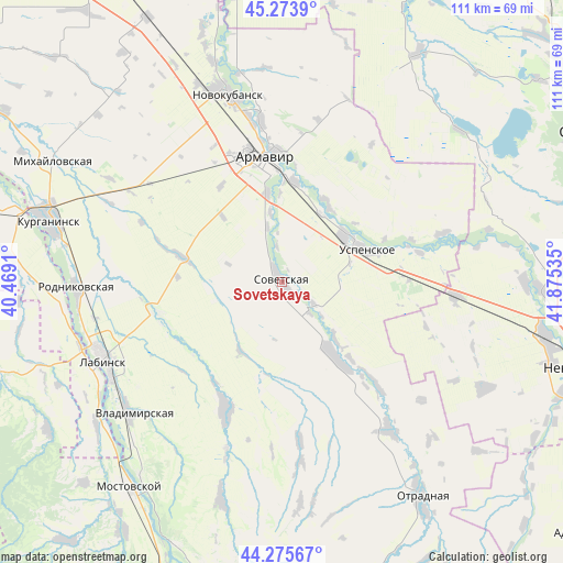
Sovetskaya GPS coordinates[2]
44° 46' 36.984" North, 41° 10' 19.992" East
| Map corner | latitude | longitude |
|---|---|---|
| Upper-left | 45.2739°, | 40.4691° |
| Center: | 44.77694°, | 41.17222° |
| Lower-right: | 44.27567°, | 41.87535° |
| Map W x H: | 111×111 km | = 69×69mi |
| max Lat: | 73.50819° ⇑88.4% North |
| Sovetskaya: | 44.77694° |
| min Lat: | ⇓11.6% South 41.28413° |
| min Long | Sovetskaya | max Long |
| -179.12198° | 41.17222° | 179.35046° |
| W 37.6%⇐ | ⇒62.4% E |
Elevation
Elevation of Sovetskaya is 287 m = 942 ft, and this is 84.4 m = 277 ft above average elevation for this country.
| Max E: |
2518 m = 8261 ft | 16.9% |
| Sovetskaya | 287 m 942 ft | |
| Avg. | 202.6 m = 665 ft | |
Min E: |
-28 m = -92 ft | 83.1% |
See also: Russia elevation on elevation.city.
Geographical zone
Sovetskaya is located in North temperate zone (between Tropic of Cancer and the Arctic Circle). Distance of this Northern Tropic circle is 2372.8 km =1474.4 mi to South.| Distance of | km | miles | from Sovetskaya |
|---|---|---|---|
| North Pole | 5028.3 | 3124.4 | to North |
| Arctic Circle | 2422.4 | 1505.2 | to North |
| Tropic Cancer | 2372.8 | 1474.4 | to South |
| Equator | 4978.7 | 3093.6 | to South |


Nearby cities:
15 places around Sovetskaya: (largest is in red/bold)
• Armavir
23.9 km =14.9 mi,  350°
350°
• Besskorbnaya
18.3 km =11.4 mi,  143°
143°
• Chamlykskaya
24.2 km =15 mi,  253°
253°
• Glubokiy
22.4 km =13.9 mi,  327°
327°
• Konokovo
15.4 km =9.6 mi,  52°
52°
• Konstantinovskaya
35.7 km =22.2 mi,  280°
280°
• Krasnaya Polyana
31.4 km =19.5 mi, 350°
• Novoalekseyevskaya
19.4 km =12.1 mi, 283°
• Prikubanskiy
25 km =15.5 mi,  1°
1°
• Prochnookopskaya
32.5 km =20.2 mi, 352°
• Staraya Stanitsa
25.9 km =16.1 mi,  356°
356°
• Uspenskoye
18.4 km =11.4 mi,  70°
70°
• Voznesenskaya
27.3 km =17 mi,  204°
204°
• Zavetnoye
33.9 km =21.1 mi,  95°
95°
• Zavetnyy
17.4 km =10.8 mi, 350°
Sources, notices
• [Note1] Compared only with cities in Russia existing in our database
• [Src1] Map data: © OpenStreetMap contributors (CC-BY-SA)
• [Src2] Other city data from geonames.org with taken over terms of usage.
• [Src3] Geographical zone / Annual Mean Temperature by Robert A. Rohde @ Wikipedia
