Armavir geodata
Armavir (Krasnodarskiy) is a populated place; located in Russia in Europe/Moscow (GMT+3) time zone. With population of 199,548 people, there are 101 cities with bigger population in this country. Compared to other cities in Russia, 87.5% of cities are located further ↑North; 62.6% of cities are located further →East and 71.2% of cities have lower elevation than Armavir. Note1


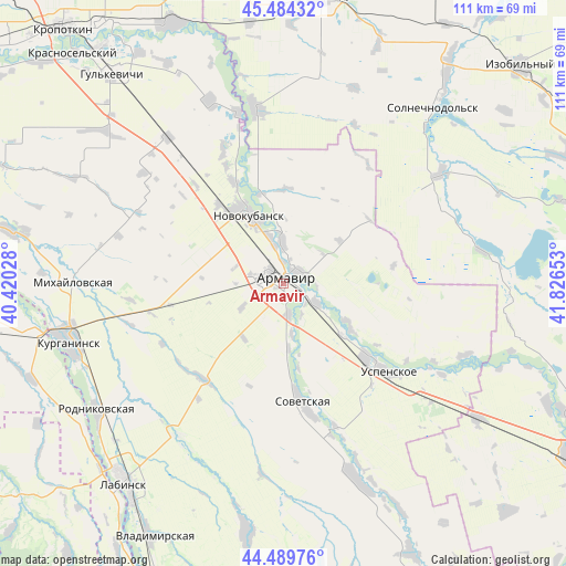
Armavir GPS coordinates[2]
44° 59' 21.12" North, 41° 7' 24.24" East
| Map corner | latitude | longitude |
|---|---|---|
| Upper-left | 45.48432°, | 40.42028° |
| Center: | 44.9892°, | 41.1234° |
| Lower-right: | 44.48976°, | 41.82653° |
| Map W x H: | 110.6×110.6 km | = 68.7×68.7mi |
| max Lat: | 73.50819° ⇑87.5% North |
| Armavir: | 44.9892° |
| min Lat: | ⇓12.5% South 41.28413° |
| min Long | Armavir | max Long |
| -179.12198° | 41.1234° | 179.35046° |
| W 37.4%⇐ | ⇒62.6% E |
Elevation
Elevation of Armavir is 201 m = 659 ft, and this is 1.6 m = 5 ft below average elevation for this country.
| Max E: |
2518 m = 8261 ft | 28.8% |
| Avg. | 202.6 m = 665 ft | |
| Armavir | 201 m = 659 ft | |
Min E: |
-28 m = -92 ft | 71.2% |
See also: Armavir elevation on elevation.city.
Geographical zone
Armavir is located in North temperate zone (between Tropic of Cancer and the Arctic Circle). Distance of this Northern Tropic circle is 2396.4 km =1489.1 mi to South.| Distance of | km | miles | from Armavir |
|---|---|---|---|
| North Pole | 5004.7 | 3109.8 | to North |
| Arctic Circle | 2398.8 | 1490.5 | to North |
| Tropic Cancer | 2396.4 | 1489.1 | to South |
| Equator | 5002.3 | 3108.3 | to South |


Nearby cities:
15 places around Armavir: (largest is in red/bold)
• Chamlykskaya
36 km =22.4 mi,  212°
212°
• Glubokiy
9.5 km =5.9 mi,  240°
240°
• Grigoropolisskaya
34.6 km =21.5 mi,  351°
351°
• Konokovo
21.4 km =13.3 mi,  131°
131°
• Konstantinovskaya
35.6 km =22.1 mi, 241°
• Kovalevskoye
25.6 km =15.9 mi,  333°
333°
• Krasnaya Polyana
7.5 km =4.7 mi, 347°
• Novoalekseyevskaya
24.1 km =15 mi,  218°
218°
• Novokubansk
16.1 km =10 mi, 331°
• Prikubanskiy
4.6 km =2.9 mi,  72°
72°
• Prochnookopskaya
8.6 km =5.3 mi,  356°
356°
• Sovetskaya
23.9 km =14.9 mi,  170°
170°
• Staraya Stanitsa
3.2 km =2 mi,  43°
43°
• Uspenskoye
27.5 km =17.1 mi, 129°
• Zavetnyy
6.5 km =4 mi, 170°
Sources, notices
• [Note1] Compared only with cities in Russia existing in our database
• [Src1] Map data: © OpenStreetMap contributors (CC-BY-SA)
• [Src2] Other city data from geonames.org with taken over terms of usage.
• [Src3] Geographical zone / Annual Mean Temperature by Robert A. Rohde @ Wikipedia
