Voznesenskaya geodata
Voznesenskaya (Krasnodarskiy) is a populated place; located in Russia in Europe/Moscow (GMT+3) time zone. With population of 7,009 people, there are 1995 cities with bigger population in this country. Compared to other cities in Russia, 89.3% of cities are located further ↑North; 63% of cities are located further →East and 87.5% of cities have lower elevation than Voznesenskaya. Note1


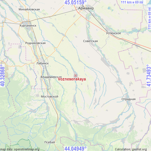
Voznesenskaya GPS coordinates[2]
44° 33' 9.72" North, 41° 1' 54.48" East
| Map corner | latitude | longitude |
|---|---|---|
| Upper-left | 45.05159°, | 40.32868° |
| Center: | 44.5527°, | 41.0318° |
| Lower-right: | 44.04949°, | 41.73493° |
| Map W x H: | 111.4×111.4 km | = 69.2×69.2mi |
| max Lat: | 73.50819° ⇑89.3% North |
| Voznesenskaya: | 44.5527° |
| min Lat: | ⇓10.7% South 41.28413° |
| min Long | Voznesenskaya | max Long |
| -179.12198° | 41.0318° | 179.35046° |
| W 37%⇐ | ⇒63% E |
Elevation
Elevation of Voznesenskaya is 385 m = 1263 ft, and this is 182.4 m = 598 ft above average elevation for this country.
| Max E: |
2518 m = 8261 ft | 12.5% |
| Voznesenskaya | 385 m 1263 ft | |
| Avg. | 202.6 m = 665 ft | |
Min E: |
-28 m = -92 ft | 87.5% |
See also: Russia elevation on elevation.city.
Geographical zone
Voznesenskaya is located in North temperate zone (between Tropic of Cancer and the Arctic Circle). Distance of this Northern Tropic circle is 2347.9 km =1458.9 mi to South.| Distance of | km | miles | from Voznesenskaya |
|---|---|---|---|
| North Pole | 5053.3 | 3140 | to North |
| Arctic Circle | 2447.4 | 1520.7 | to North |
| Tropic Cancer | 2347.9 | 1458.9 | to South |
| Equator | 4953.8 | 3078.1 | to South |


Nearby cities:
15 places around Voznesenskaya: (largest is in red/bold)
• Besskorbnaya
24.4 km =15.2 mi,  65°
65°
• Chamlykskaya
21.8 km =13.5 mi,  326°
326°
• Khodz’
25.6 km =15.9 mi,  259°
259°
• Konstantinovskaya
39.6 km =24.6 mi,  322°
322°
• Labinsk
25.1 km =15.6 mi,  291°
291°
• Mostovskoy
24.5 km =15.2 mi,  230°
230°
• Natyrbovo
37.6 km =23.4 mi,  301°
301°
• Novoalekseyevskaya
30.6 km =19 mi,  345°
345°
• Perepravnaya
31 km =19.3 mi,  219°
219°
• Poputnaya
32.6 km =20.3 mi,  97°
97°
• Rodnikovskaya
37.3 km =23.2 mi,  309°
309°
• Shedok
40 km =24.9 mi,  201°
201°
• Sovetskaya
27.3 km =17 mi,  24°
24°
• Upornaya
18 km =11.2 mi,  183°
183°
• Vladimirskaya
18.9 km =11.7 mi,  267°
267°
Sources, notices
• [Note1] Compared only with cities in Russia existing in our database
• [Src1] Map data: © OpenStreetMap contributors (CC-BY-SA)
• [Src2] Other city data from geonames.org with taken over terms of usage.
• [Src3] Geographical zone / Annual Mean Temperature by Robert A. Rohde @ Wikipedia
