Sotnikovskoye geodata
Sotnikovskoye (Stavropol’ Kray) is a populated place; located in Russia in Europe/Moscow (GMT+3) time zone. With population of 5,116 people, there are 2602 cities with bigger population in this country. Compared to other cities in Russia, 87.4% of cities are located further ↑North; 53.6% of cities are located further →East and 59.2% of cities have higher elevation than Sotnikovskoye. Note1


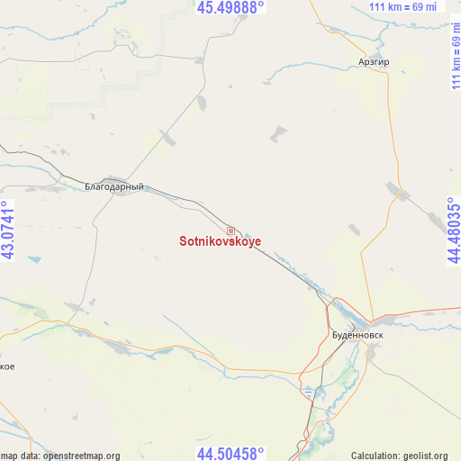
Sotnikovskoye GPS coordinates[2]
45° 0' 14.004" North, 43° 46' 37.992" East
| Map corner | latitude | longitude |
|---|---|---|
| Upper-left | 45.49888°, | 43.0741° |
| Center: | 45.00389°, | 43.77722° |
| Lower-right: | 44.50458°, | 44.48035° |
| Map W x H: | 110.6×110.6 km | = 68.7×68.7mi |
| max Lat: | 73.50819° ⇑87.4% North |
| Sotnikovskoye: | 45.00389° |
| min Lat: | ⇓12.6% South 41.28413° |
| min Long | Sotnikovskoye | max Long |
| -179.12198° | 43.77722° | 179.35046° |
| W 46.4%⇐ | ⇒53.6% E |
Elevation
Elevation of Sotnikovskoye is 126 m = 413 ft, and this is 76.6 m = 251 ft below average elevation for this country.
| Max E: |
2518 m = 8261 ft | 59.2% |
| Avg. | 202.6 m = 665 ft | |
| Sotnikovskoye | 126 m = 413 ft | |
Min E: |
-28 m = -92 ft | 40.8% |
See also: Russia elevation on elevation.city.
Geographical zone
Sotnikovskoye is located in North temperate zone (between Tropic of Cancer and the Arctic Circle). Distance of this North polar circle is 2397.2 km =1489.6 mi to North.| Distance of | km | miles | from Sotnikovskoye |
|---|---|---|---|
| North Pole | 5003.1 | 3108.8 | to North |
| Arctic Circle | 2397.2 | 1489.6 | to North |
| Tropic Cancer | 2398 | 1490 | to South |
| Equator | 5004 | 3109.3 | to South |


Nearby cities:
15 places around Sotnikovskoye: (largest is in red/bold)
• Aleksandriya
43 km =26.7 mi,  283°
283°
• Arzgir
53.8 km =33.4 mi,  40°
40°
• Blagodarnyy
28.7 km =17.8 mi,  291°
291°
• Budënnovsk
39.2 km =24.4 mi,  128°
128°
• Burlatskoye
12.6 km =7.8 mi,  297°
297°
• Chernolesskoye
32.5 km =20.2 mi,  188°
188°
• Gofitskoye
58 km =36 mi, 278°
• Letnyaya Stavka
54 km =33.6 mi,  331°
331°
• Novoselitskoye
38.9 km =24.2 mi,  223°
223°
• Orlovka
46.8 km =29.1 mi,  137°
137°
• Ovoshchi
53.8 km =33.4 mi,  318°
318°
• Pokoynoye
43.2 km =26.8 mi,  120°
120°
• Praskoveya
44.3 km =27.5 mi, 130°
• Starodubskoye
52.5 km =32.6 mi,  159°
159°
• Yelizavetinskoye
33.6 km =20.9 mi,  270°
270°
Sources, notices
• [Note1] Compared only with cities in Russia existing in our database
• [Src1] Map data: © OpenStreetMap contributors (CC-BY-SA)
• [Src2] Other city data from geonames.org with taken over terms of usage.
• [Src3] Geographical zone / Annual Mean Temperature by Robert A. Rohde @ Wikipedia
