Praskoveya geodata
Praskoveya (Stavropol’ Kray) is a populated place; located in Russia in Europe/Moscow (GMT+3) time zone. With population of 11,420 people, there are 1331 cities with bigger population in this country. Compared to other cities in Russia, 88.6% of cities are located further ↑North; 52.3% of cities are located further →East and 65.3% of cities have higher elevation than Praskoveya. Note1


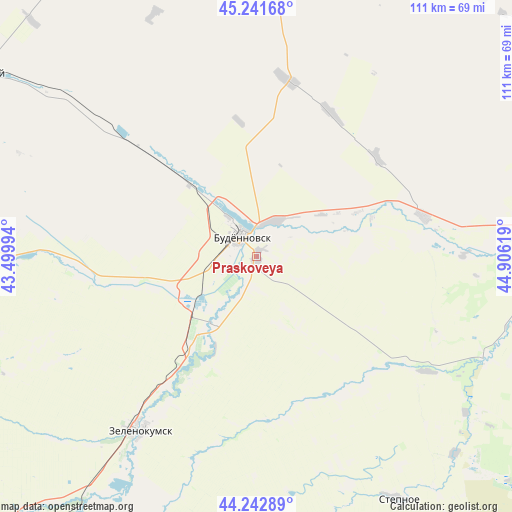
Praskoveya GPS coordinates[2]
44° 44' 39.984" North, 44° 12' 11.016" East
| Map corner | latitude | longitude |
|---|---|---|
| Upper-left | 45.24168°, | 43.49994° |
| Center: | 44.74444°, | 44.20306° |
| Lower-right: | 44.24289°, | 44.90619° |
| Map W x H: | 111.1×111.1 km | = 69×69mi |
| max Lat: | 73.50819° ⇑88.6% North |
| Praskoveya: | 44.74444° |
| min Lat: | ⇓11.4% South 41.28413° |
| min Long | Praskoveya | max Long |
| -179.12198° | 44.20306° | 179.35046° |
| W 47.7%⇐ | ⇒52.3% E |
Elevation
Elevation of Praskoveya is 113 m = 371 ft, and this is 89.6 m = 294 ft below average elevation for this country.
| Max E: |
2518 m = 8261 ft | 65.3% |
| Avg. | 202.6 m = 665 ft | |
| Praskoveya | 113 m = 371 ft | |
Min E: |
-28 m = -92 ft | 34.7% |
See also: Russia elevation on elevation.city.
Geographical zone
Praskoveya is located in North temperate zone (between Tropic of Cancer and the Arctic Circle). Distance of this Northern Tropic circle is 2369.2 km =1472.2 mi to South.| Distance of | km | miles | from Praskoveya |
|---|---|---|---|
| North Pole | 5031.9 | 3126.7 | to North |
| Arctic Circle | 2426.1 | 1507.5 | to North |
| Tropic Cancer | 2369.2 | 1472.2 | to South |
| Equator | 4975.1 | 3091.4 | to South |


Nearby cities:
15 places around Praskoveya: (largest is in red/bold)
• Achikulak
54.6 km =33.9 mi,  113°
113°
• Budënnovsk
5.3 km =3.3 mi,  326°
326°
• Burlatskoye
56.6 km =35.2 mi,  307°
307°
• Chernolesskoye
38.8 km =24.1 mi,  265°
265°
• Levokumskoye
37.1 km =23.1 mi,  76°
76°
• Niny
34.9 km =21.7 mi,  215°
215°
• Orlovka
6.3 km =3.9 mi,  200°
200°
• Otkaznoye
53.8 km =33.4 mi,  210°
210°
• Pokoynoye
8.2 km =5.1 mi,  27°
27°
• Pravokumskoye
35.2 km =21.9 mi,  85°
85°
• Sotnikovskoye
44.3 km =27.5 mi, 310°
• Starodubskoye
25 km =15.5 mi, 216°
• Urozhaynoye
57 km =35.4 mi, 85°
• Vostochny
47.8 km =29.7 mi,  180°
180°
• Zelenokumsk
45.4 km =28.2 mi, 214°
Sources, notices
• [Note1] Compared only with cities in Russia existing in our database
• [Src1] Map data: © OpenStreetMap contributors (CC-BY-SA)
• [Src2] Other city data from geonames.org with taken over terms of usage.
• [Src3] Geographical zone / Annual Mean Temperature by Robert A. Rohde @ Wikipedia
