Shlissel’burg geodata
Shlissel’burg (Leningradskaya Oblast') is a populated place; located in Russia in Europe/Moscow (GMT+3) time zone. With population of 12,115 people, there are 1262 cities with bigger population in this country. Compared to other cities in Russia, 89.8% of cities are located further ↓South; 94.5% of cities are located further →East and 95.2% of cities have higher elevation than Shlissel’burg. Note1


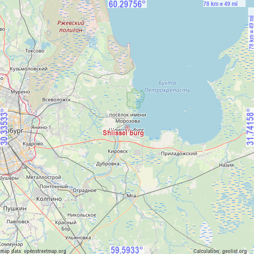
Shlissel’burg GPS coordinates[2]
59° 56' 50.28" North, 31° 2' 18.42" East
| Map corner | latitude | longitude |
|---|---|---|
| Upper-left | 60.29756°, | 30.33533° |
| Center: | 59.9473°, | 31.03845° |
| Lower-right: | 59.5933°, | 31.74158° |
| Map W x H: | 78.3×78.3 km | = 48.7×48.7mi |
| max Lat: | 73.50819° ⇑10.2% North |
| Shlissel’burg: | 59.9473° |
| min Lat: | ⇓89.8% South 41.28413° |
| min Long | Shlissel’burg | max Long |
| -179.12198° | 31.03845° | 179.35046° |
| W 5.5%⇐ | ⇒94.5% E |
Elevation
Elevation of Shlissel’burg is 12 m = 39 ft, and this is 190.6 m = 625 ft below average elevation for this country.
| Max E: |
2518 m = 8261 ft | 95.2% |
| Avg. | 202.6 m = 665 ft | |
| Shlissel’burg | 12 m = 39 ft | |
Min E: |
-28 m = -92 ft | 4.8% |
See also: Russia elevation on elevation.city.
Geographical zone
Shlissel’burg is located in North temperate zone (between Tropic of Cancer and the Arctic Circle). Distance of this North polar circle is 735.7 km =457.1 mi to North.| Distance of | km | miles | from Shlissel’burg |
|---|---|---|---|
| North Pole | 3341.5 | 2076.3 | to North |
| Arctic Circle | 735.7 | 457.1 | to North |
| Tropic Cancer | 4059.6 | 2522.5 | to South |
| Equator | 6665.5 | 4141.7 | to South |


Nearby cities:
15 places around Shlissel’burg: (largest is in red/bold)
• Borisova Griva
16.2 km =10.1 mi,  347°
347°
• Imeni Morozova
3.2 km =2 mi,  359°
359°
• Imeni Sverdlova
26.7 km =16.6 mi,  231°
231°
• Kirovsk
7.8 km =4.8 mi,  198°
198°
• Koltushi
22 km =13.7 mi,  264°
264°
• Mga
22 km =13.7 mi,  175°
175°
• Otradnoye
22.5 km =14 mi,  213°
213°
• Pavlovo
17.3 km =10.7 mi, 207°
• Priladozhskiy
27.1 km =16.8 mi,  113°
113°
• Romanovka
21 km =13 mi,  300°
300°
• Shcheglovo
18.3 km =11.4 mi, 299°
• Sinyavino
4.8 km =3 mi,  157°
157°
• Staraya
23 km =14.3 mi, 264°
• Vsevolozhsk
21.7 km =13.5 mi,  290°
290°
• Yanino-1
26.7 km =16.6 mi,  270°
270°
Sources, notices
• [Note1] Compared only with cities in Russia existing in our database
• [Src1] Map data: © OpenStreetMap contributors (CC-BY-SA)
• [Src2] Other city data from geonames.org with taken over terms of usage.
• [Src3] Geographical zone / Annual Mean Temperature by Robert A. Rohde @ Wikipedia
