Pavlovo geodata
Pavlovo (Leningradskaya Oblast') is a populated place; located in Russia in Europe/Moscow (GMT+3) time zone. With population of 3,348 people, there are 3499 cities with bigger population in this country. Compared to other cities in Russia, 89.1% of cities are located further ↓South; 94.6% of cities are located further →East and 93.3% of cities have higher elevation than Pavlovo. Note1


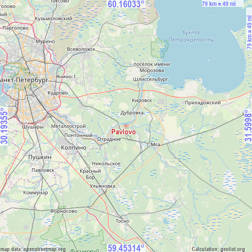
Pavlovo GPS coordinates[2]
59° 48' 30.996" North, 30° 53' 48.012" East
| Map corner | latitude | longitude |
|---|---|---|
| Upper-left | 60.16033°, | 30.19355° |
| Center: | 59.80861°, | 30.89667° |
| Lower-right: | 59.45314°, | 31.5998° |
| Map W x H: | 78.6×78.6 km | = 48.8×48.8mi |
| max Lat: | 73.50819° ⇑10.9% North |
| Pavlovo: | 59.80861° |
| min Lat: | ⇓89.1% South 41.28413° |
| min Long | Pavlovo | max Long |
| -179.12198° | 30.89667° | 179.35046° |
| W 5.4%⇐ | ⇒94.6% E |
Elevation
Elevation of Pavlovo is 17 m = 56 ft, and this is 185.6 m = 609 ft below average elevation for this country.
| Max E: |
2518 m = 8261 ft | 93.3% |
| Avg. | 202.6 m = 665 ft | |
| Pavlovo | 17 m = 56 ft | |
Min E: |
-28 m = -92 ft | 6.7% |
See also: Russia elevation on elevation.city.
Geographical zone
Pavlovo is located in North temperate zone (between Tropic of Cancer and the Arctic Circle). Distance of this North polar circle is 751.1 km =466.7 mi to North.| Distance of | km | miles | from Pavlovo |
|---|---|---|---|
| North Pole | 3357 | 2085.9 | to North |
| Arctic Circle | 751.1 | 466.7 | to North |
| Tropic Cancer | 4044.2 | 2512.9 | to South |
| Equator | 6650.1 | 4132.2 | to South |


Nearby cities:
15 places around Pavlovo: (largest is in red/bold)
• Imeni Sverdlova
13 km =8.1 mi,  263°
263°
• Kirovsk
9.7 km =6 mi,  34°
34°
• Kolpino
18.4 km =11.4 mi,  249°
249°
• Koltushi
19.5 km =12.1 mi,  313°
313°
• Krasnyy Bor
19 km =11.8 mi,  222°
222°
• Metallostroy
19.5 km =12.1 mi,  267°
267°
• Mga
11.5 km =7.1 mi,  124°
124°
• Nikol’skoye
13.6 km =8.5 mi,  207°
207°
• Otradnoye
5.6 km =3.5 mi,  231°
231°
• Pontonnyy
15.9 km =9.9 mi, 261°
• Sapërnyy
13.6 km =8.5 mi, 254°
• Shlissel’burg
17.3 km =10.7 mi, 27°
• Sinyavino
14.7 km =9.1 mi,  41°
41°
• Staraya
20 km =12.4 mi, 311°
• Ust’-Izhora
17.6 km =10.9 mi, 271°
Sources, notices
• [Note1] Compared only with cities in Russia existing in our database
• [Src1] Map data: © OpenStreetMap contributors (CC-BY-SA)
• [Src2] Other city data from geonames.org with taken over terms of usage.
• [Src3] Geographical zone / Annual Mean Temperature by Robert A. Rohde @ Wikipedia
