Shilovo geodata
Shilovo (Voronezj) is a populated place; located in Russia in Europe/Moscow (GMT+3) time zone. With population of 6,728 people, there are 2064 cities with bigger population in this country. Compared to other cities in Russia, 72.2% of cities are located further ↑North; 71.7% of cities are located further →East and 74.4% of cities have higher elevation than Shilovo. Note1


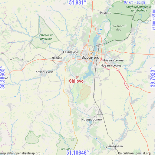
Shilovo GPS coordinates[2]
51° 32' 44.988" North, 39° 5' 21.012" East
| Map corner | latitude | longitude |
|---|---|---|
| Upper-left | 51.981°, | 38.38605° |
| Center: | 51.54583°, | 39.08917° |
| Lower-right: | 51.10646°, | 39.7923° |
| Map W x H: | 97.2×97.2 km | = 60.4×60.4mi |
| max Lat: | 73.50819° ⇑72.2% North |
| Shilovo: | 51.54583° |
| min Lat: | ⇓27.8% South 41.28413° |
| min Long | Shilovo | max Long |
| -179.12198° | 39.08917° | 179.35046° |
| W 28.3%⇐ | ⇒71.7% E |
Elevation
Elevation of Shilovo is 90 m = 295 ft, and this is 112.6 m = 369 ft below average elevation for this country.
| Max E: |
2518 m = 8261 ft | 74.4% |
| Avg. | 202.6 m = 665 ft | |
| Shilovo | 90 m = 295 ft | |
Min E: |
-28 m = -92 ft | 25.6% |
See also: Russia elevation on elevation.city.
Geographical zone
Shilovo is located in North temperate zone (between Tropic of Cancer and the Arctic Circle). Distance of this North polar circle is 1669.8 km =1037.6 mi to North.| Distance of | km | miles | from Shilovo |
|---|---|---|---|
| North Pole | 4275.7 | 2656.8 | to North |
| Arctic Circle | 1669.8 | 1037.6 | to North |
| Tropic Cancer | 3125.4 | 1942 | to South |
| Equator | 5731.4 | 3561.3 | to South |


Nearby cities:
15 places around Shilovo: (largest is in red/bold)
• Devitsa
14.1 km =8.8 mi,  314°
314°
• Kolodeznyy
24.5 km =15.2 mi,  164°
164°
• Kostenki
17.4 km =10.8 mi,  192°
192°
• Latnaya
18.1 km =11.2 mi, 313°
• Maslovka
10.2 km =6.3 mi,  85°
85°
• Novaya Usman’
24.5 km =15.2 mi,  64°
64°
• Novovoronezh
28 km =17.4 mi, 161°
• Novozhivotinnoye
38.4 km =23.9 mi,  8°
8°
• Podgornoye
21.4 km =13.3 mi, 11°
• Podkletnoye
26.3 km =16.3 mi,  79°
79°
• Pridonskoy
15.4 km =9.6 mi,  355°
355°
• Semiluki
16.1 km =10 mi,  344°
344°
• Somovo
28.9 km =18 mi,  41°
41°
• Strelitsa
14.2 km =8.8 mi,  299°
299°
• Voronezh
15.5 km =9.6 mi,  25°
25°
Sources, notices
• [Note1] Compared only with cities in Russia existing in our database
• [Src1] Map data: © OpenStreetMap contributors (CC-BY-SA)
• [Src2] Other city data from geonames.org with taken over terms of usage.
• [Src3] Geographical zone / Annual Mean Temperature by Robert A. Rohde @ Wikipedia
