Latnaya geodata
Latnaya (Voronezj) is a populated place; located in Russia in Europe/Moscow (GMT+3) time zone. With population of 7,232 people, there are 1947 cities with bigger population in this country. Compared to other cities in Russia, 71.5% of cities are located further ↑North; 72.6% of cities are located further →East and 57.8% of cities have lower elevation than Latnaya. Note1


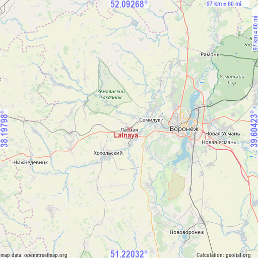
Latnaya GPS coordinates[2]
51° 39' 30.96" North, 38° 54' 3.96" East
| Map corner | latitude | longitude |
|---|---|---|
| Upper-left | 52.09268°, | 38.19798° |
| Center: | 51.6586°, | 38.9011° |
| Lower-right: | 51.22032°, | 39.60423° |
| Map W x H: | 97×97 km | = 60.3×60.3mi |
| max Lat: | 73.50819° ⇑71.5% North |
| Latnaya: | 51.6586° |
| min Lat: | ⇓28.5% South 41.28413° |
| min Long | Latnaya | max Long |
| -179.12198° | 38.9011° | 179.35046° |
| W 27.4%⇐ | ⇒72.6% E |
Elevation
Elevation of Latnaya is 163 m = 535 ft, and this is 39.6 m = 130 ft below average elevation for this country.
| Max E: |
2518 m = 8261 ft | 42.2% |
| Avg. | 202.6 m = 665 ft | |
| Latnaya | 163 m = 535 ft | |
Min E: |
-28 m = -92 ft | 57.8% |
See also: Russia elevation on elevation.city.
Geographical zone
Latnaya is located in North temperate zone (between Tropic of Cancer and the Arctic Circle). Distance of this North polar circle is 1657.3 km =1029.8 mi to North.| Distance of | km | miles | from Latnaya |
|---|---|---|---|
| North Pole | 4263.2 | 2649 | to North |
| Arctic Circle | 1657.3 | 1029.8 | to North |
| Tropic Cancer | 3138 | 1949.9 | to South |
| Equator | 5743.9 | 3569.1 | to South |


Nearby cities:
15 places around Latnaya: (largest is in red/bold)
• Devitsa
4 km =2.5 mi,  130°
130°
• Kostenki
31 km =19.3 mi,  162°
162°
• Maslovka
25.9 km =16.1 mi,  116°
116°
• Nizhnedevitsk
39.2 km =24.4 mi,  250°
250°
• Novaya Usman’
35.1 km =21.8 mi,  93°
93°
• Novozhivotinnoye
31.4 km =19.5 mi,  35°
35°
• Podgornoye
19.1 km =11.9 mi,  63°
63°
• Podkletnoye
39.5 km =24.5 mi,  101°
101°
• Pridonskoy
12.2 km =7.6 mi,  76°
76°
• Semiluki
9.2 km =5.7 mi,  71°
71°
• Shilovo
18.1 km =11.2 mi, 133°
• Somovo
33.4 km =20.8 mi, 74°
• Strelitsa
5.6 km =3.5 mi,  173°
173°
• Voronezh
19.6 km =12.2 mi, 85°
• Zemlyansk
29.6 km =18.4 mi,  337°
337°
Sources, notices
• [Note1] Compared only with cities in Russia existing in our database
• [Src1] Map data: © OpenStreetMap contributors (CC-BY-SA)
• [Src2] Other city data from geonames.org with taken over terms of usage.
• [Src3] Geographical zone / Annual Mean Temperature by Robert A. Rohde @ Wikipedia
