Strelitsa geodata
Strelitsa (Voronezj) is a populated place; located in Russia in Europe/Moscow (GMT+3) time zone. With population of 4,761 people, there are 2755 cities with bigger population in this country. Compared to other cities in Russia, 71.9% of cities are located further ↑North; 72.6% of cities are located further →East and 62% of cities have higher elevation than Strelitsa. Note1


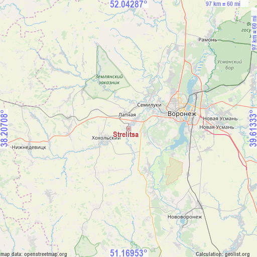
Strelitsa GPS coordinates[2]
51° 36' 29.88" North, 38° 54' 36.72" East
| Map corner | latitude | longitude |
|---|---|---|
| Upper-left | 52.04287°, | 38.20708° |
| Center: | 51.6083°, | 38.9102° |
| Lower-right: | 51.16953°, | 39.61333° |
| Map W x H: | 97.1×97.1 km | = 60.3×60.3mi |
| max Lat: | 73.50819° ⇑71.9% North |
| Strelitsa: | 51.6083° |
| min Lat: | ⇓28.1% South 41.28413° |
| min Long | Strelitsa | max Long |
| -179.12198° | 38.9102° | 179.35046° |
| W 27.4%⇐ | ⇒72.6% E |
Elevation
Elevation of Strelitsa is 120 m = 394 ft, and this is 82.6 m = 271 ft below average elevation for this country.
| Max E: |
2518 m = 8261 ft | 62% |
| Avg. | 202.6 m = 665 ft | |
| Strelitsa | 120 m = 394 ft | |
Min E: |
-28 m = -92 ft | 38% |
See also: Russia elevation on elevation.city.
Geographical zone
Strelitsa is located in North temperate zone (between Tropic of Cancer and the Arctic Circle). Distance of this North polar circle is 1662.9 km =1033.3 mi to North.| Distance of | km | miles | from Strelitsa |
|---|---|---|---|
| North Pole | 4268.8 | 2652.5 | to North |
| Arctic Circle | 1662.9 | 1033.3 | to North |
| Tropic Cancer | 3132.4 | 1946.4 | to South |
| Equator | 5738.3 | 3565.6 | to South |


Nearby cities:
15 places around Strelitsa: (largest is in red/bold)
• Devitsa
3.8 km =2.4 mi,  38°
38°
• Kolodeznyy
36 km =22.4 mi,  148°
148°
• Kostenki
25.5 km =15.8 mi,  160°
160°
• Latnaya
5.6 km =3.5 mi,  353°
353°
• Maslovka
23.3 km =14.5 mi,  105°
105°
• Novaya Usman’
34.6 km =21.5 mi,  83°
83°
• Novozhivotinnoye
35.8 km =22.2 mi,  29°
29°
• Podgornoye
21.7 km =13.5 mi,  49°
49°
• Podkletnoye
38.2 km =23.7 mi,  93°
93°
• Pridonskoy
14 km =8.7 mi, 53°
• Semiluki
11.8 km =7.3 mi, 43°
• Shilovo
14.2 km =8.8 mi,  119°
119°
• Somovo
34.8 km =21.6 mi,  64°
64°
• Voronezh
20.2 km =12.6 mi,  69°
69°
• Zemlyansk
35.1 km =21.8 mi,  339°
339°
Sources, notices
• [Note1] Compared only with cities in Russia existing in our database
• [Src1] Map data: © OpenStreetMap contributors (CC-BY-SA)
• [Src2] Other city data from geonames.org with taken over terms of usage.
• [Src3] Geographical zone / Annual Mean Temperature by Robert A. Rohde @ Wikipedia
