Shestikhino geodata
Shestikhino (Jaroslavl) is a populated place; located in Russia in Europe/Moscow (GMT+3) time zone. With population of 596 people, there are 4898 cities with bigger population in this country. Compared to other cities in Russia, 82.4% of cities are located further ↓South; 75.6% of cities are located further →East and 60.6% of cities have higher elevation than Shestikhino. Note1


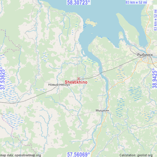
Shestikhino GPS coordinates[2]
57° 56' 9.24" North, 38° 14' 21.732" East
| Map corner | latitude | longitude |
|---|---|---|
| Upper-left | 58.30723°, | 37.53625° |
| Center: | 57.9359°, | 38.23937° |
| Lower-right: | 57.56069°, | 38.9425° |
| Map W x H: | 83×83 km | = 51.6×51.6mi |
| max Lat: | 73.50819° ⇑17.6% North |
| Shestikhino: | 57.9359° |
| min Lat: | ⇓82.4% South 41.28413° |
| min Long | Shestikhino | max Long |
| -179.12198° | 38.23937° | 179.35046° |
| W 24.4%⇐ | ⇒75.6% E |
Elevation
Elevation of Shestikhino is 123 m = 404 ft, and this is 79.6 m = 261 ft below average elevation for this country.
| Max E: |
2518 m = 8261 ft | 60.6% |
| Avg. | 202.6 m = 665 ft | |
| Shestikhino | 123 m = 404 ft | |
Min E: |
-28 m = -92 ft | 39.4% |
See also: Russia elevation on elevation.city.
Geographical zone
Shestikhino is located in North temperate zone (between Tropic of Cancer and the Arctic Circle). Distance of this North polar circle is 959.3 km =596.1 mi to North.| Distance of | km | miles | from Shestikhino |
|---|---|---|---|
| North Pole | 3565.2 | 2215.3 | to North |
| Arctic Circle | 959.3 | 596.1 | to North |
| Tropic Cancer | 3835.9 | 2383.5 | to South |
| Equator | 6441.9 | 4002.8 | to South |


Nearby cities:
15 places around Shestikhino: (largest is in red/bold)
• Bol’shoye Selo
47.7 km =29.6 mi,  120°
120°
• Borok
14.4 km =8.9 mi,  359°
359°
• Breytovo
46.1 km =28.6 mi,  331°
331°
• Kashin
74.3 km =46.2 mi,  210°
210°
• Kesova Gora
68.5 km =42.6 mi,  235°
235°
• Krasnyy Kholm
67.4 km =41.9 mi,  281°
281°
• Myshkin
20.6 km =12.8 mi,  141°
141°
• Novyy Nekouz
10.7 km =6.6 mi,  249°
249°
• Pesochnoye
55.8 km =34.7 mi,  81°
81°
• Rybinsk
37.6 km =23.4 mi,  71°
71°
• Sonkovo
66.4 km =41.3 mi, 254°
• Sudoverf’
31.1 km =19.3 mi,  49°
49°
• Tutayev
77.1 km =47.9 mi,  94°
94°
• Uglich
45.7 km =28.4 mi,  173°
173°
• Volga
8.9 km =5.5 mi, 78°
Sources, notices
• [Note1] Compared only with cities in Russia existing in our database
• [Src1] Map data: © OpenStreetMap contributors (CC-BY-SA)
• [Src2] Other city data from geonames.org with taken over terms of usage.
• [Src3] Geographical zone / Annual Mean Temperature by Robert A. Rohde @ Wikipedia
