Uglich geodata
Uglich (Jaroslavl) is a populated place; located in Russia in Europe/Moscow (GMT+3) time zone. With population of 37,732 people, there are 551 cities with bigger population in this country. Compared to other cities in Russia, 80.2% of cities are located further ↓South; 75.2% of cities are located further →East and 62% of cities have higher elevation than Uglich. Note1


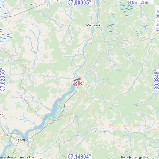
Uglich GPS coordinates[2]
57° 31' 39" North, 38° 19' 54.012" East
| Map corner | latitude | longitude |
|---|---|---|
| Upper-left | 57.90305°, | 37.62855° |
| Center: | 57.5275°, | 38.33167° |
| Lower-right: | 57.14804°, | 39.0348° |
| Map W x H: | 83.9×83.9 km | = 52.1×52.1mi |
| max Lat: | 73.50819° ⇑19.8% North |
| Uglich: | 57.5275° |
| min Lat: | ⇓80.2% South 41.28413° |
| min Long | Uglich | max Long |
| -179.12198° | 38.33167° | 179.35046° |
| W 24.8%⇐ | ⇒75.2% E |
Elevation
Elevation of Uglich is 120 m = 394 ft, and this is 82.6 m = 271 ft below average elevation for this country.
| Max E: |
2518 m = 8261 ft | 62% |
| Avg. | 202.6 m = 665 ft | |
| Uglich | 120 m = 394 ft | |
Min E: |
-28 m = -92 ft | 38% |
See also: Russia elevation on elevation.city.
Geographical zone
Uglich is located in North temperate zone (between Tropic of Cancer and the Arctic Circle). Distance of this North polar circle is 1004.7 km =624.3 mi to North.| Distance of | km | miles | from Uglich |
|---|---|---|---|
| North Pole | 3610.6 | 2243.5 | to North |
| Arctic Circle | 1004.7 | 624.3 | to North |
| Tropic Cancer | 3790.5 | 2355.3 | to South |
| Equator | 6396.5 | 3974.6 | to South |


Nearby cities:
15 places around Uglich: (largest is in red/bold)
• Bol’shoye Selo
41.6 km =25.8 mi,  59°
59°
• Borisoglebskiy
57.5 km =35.7 mi,  121°
121°
• Borok
60.1 km =37.3 mi,  354°
354°
• Kalyazin
43.3 km =26.9 mi,  222°
222°
• Kashin
47.2 km =29.3 mi,  246°
246°
• Kesova Gora
62.3 km =38.7 mi,  275°
275°
• Kurba
69.7 km =43.3 mi,  86°
86°
• Leont’yevskoye
36.4 km =22.6 mi,  211°
211°
• Myshkin
30.1 km =18.7 mi,  14°
14°
• Nerl’
57.1 km =35.5 mi,  201°
201°
• Novyy Nekouz
44.5 km =27.7 mi,  339°
339°
• Rybinsk
65 km =40.4 mi,  27°
27°
• Shestikhino
45.7 km =28.4 mi, 353°
• Sudoverf’
68.1 km =42.3 mi,  15°
15°
• Volga
47.3 km =29.4 mi,  4°
4°
Sources, notices
• [Note1] Compared only with cities in Russia existing in our database
• [Src1] Map data: © OpenStreetMap contributors (CC-BY-SA)
• [Src2] Other city data from geonames.org with taken over terms of usage.
• [Src3] Geographical zone / Annual Mean Temperature by Robert A. Rohde @ Wikipedia
