Shemursha geodata
Shemursha (Chuvashia) is a populated place; located in Russia in Europe/Moscow (GMT+3) time zone. With population of 3,690 people, there are 3279 cities with bigger population in this country. Compared to other cities in Russia, 52% of cities are located further ↓South; 57.5% of cities are located further ←West and 56.8% of cities have lower elevation than Shemursha. Note1


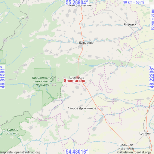
Shemursha GPS coordinates[2]
54° 53' 11.868" North, 47° 31' 8.148" East
| Map corner | latitude | longitude |
|---|---|---|
| Upper-left | 55.28904°, | 46.81581° |
| Center: | 54.88663°, | 47.51893° |
| Lower-right: | 54.48016°, | 48.22206° |
| Map W x H: | 89.9×89.9 km | = 55.9×55.9mi |
| max Lat: | 73.50819° ⇑48% North |
| Shemursha: | 54.88663° |
| min Lat: | ⇓52% South 41.28413° |
| min Long | Shemursha | max Long |
| -179.12198° | 47.51893° | 179.35046° |
| W 57.5%⇐ | ⇒42.5% E |
Elevation
Elevation of Shemursha is 160 m = 525 ft, and this is 42.6 m = 140 ft below average elevation for this country.
| Max E: |
2518 m = 8261 ft | 43.2% |
| Avg. | 202.6 m = 665 ft | |
| Shemursha | 160 m = 525 ft | |
Min E: |
-28 m = -92 ft | 56.8% |
See also: Russia elevation on elevation.city.
Geographical zone
Shemursha is located in North temperate zone (between Tropic of Cancer and the Arctic Circle). Distance of this North polar circle is 1298.4 km =806.8 mi to North.| Distance of | km | miles | from Shemursha |
|---|---|---|---|
| North Pole | 3904.2 | 2426 | to North |
| Arctic Circle | 1298.4 | 806.8 | to North |
| Tropic Cancer | 3496.9 | 2172.9 | to South |
| Equator | 6102.8 | 3792.1 | to South |


Nearby cities:
15 places around Shemursha: (largest is in red/bold)
• Alatyr’
60.2 km =37.4 mi,  265°
265°
• Apastovo
72.3 km =44.9 mi,  60°
60°
• Batyrevo
21 km =13 mi,  16°
16°
• Buinsk
45 km =28 mi,  319°
319°
• Buinsk
50.3 km =31.3 mi,  79°
79°
• Ibresi
55.3 km =34.4 mi,  326°
326°
• Isheyevka
70.1 km =43.6 mi,  136°
136°
• Kanash
69.3 km =43.1 mi,  358°
358°
• Kirya
47.2 km =29.3 mi,  297°
297°
• Komsomol'skoye
41.2 km =25.6 mi,  2°
2°
• Staroye Drozhzhanoye
18.1 km =11.2 mi,  170°
170°
• Surskoye
68.2 km =42.4 mi,  228°
228°
• Tsil’na
51.4 km =31.9 mi,  129°
129°
• Undory
64 km =39.8 mi,  118°
118°
• Yazykovo
66.6 km =41.4 mi,  187°
187°
Sources, notices
• [Note1] Compared only with cities in Russia existing in our database
• [Src1] Map data: © OpenStreetMap contributors (CC-BY-SA)
• [Src2] Other city data from geonames.org with taken over terms of usage.
• [Src3] Geographical zone / Annual Mean Temperature by Robert A. Rohde @ Wikipedia
