Komsomol'skoye geodata
Komsomol'skoye (Chuvashia) is a populated place; located in Russia in Europe/Moscow (GMT+3) time zone. With population of 4,839 people, there are 2730 cities with bigger population in this country. Compared to other cities in Russia, 55.8% of cities are located further ↓South; 57.6% of cities are located further ←West and 63% of cities have higher elevation than Komsomol'skoye. Note1


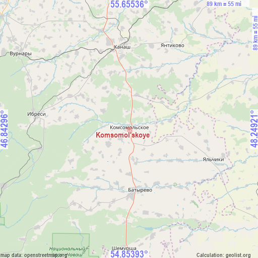
Komsomol'skoye GPS coordinates[2]
55° 15' 24.012" North, 47° 32' 45.888" East
| Map corner | latitude | longitude |
|---|---|---|
| Upper-left | 55.65536°, | 46.84296° |
| Center: | 55.25667°, | 47.54608° |
| Lower-right: | 54.85393°, | 48.24921° |
| Map W x H: | 89.1×89.1 km | = 55.4×55.4mi |
| max Lat: | 73.50819° ⇑44.2% North |
| Komsomol'skoye: | 55.25667° |
| min Lat: | ⇓55.8% South 41.28413° |
| min Long | Komsomol'skoye | max Long |
| -179.12198° | 47.54608° | 179.35046° |
| W 57.6%⇐ | ⇒42.4% E |
Elevation
Elevation of Komsomol'skoye is 118 m = 387 ft, and this is 84.6 m = 278 ft below average elevation for this country.
| Max E: |
2518 m = 8261 ft | 63% |
| Avg. | 202.6 m = 665 ft | |
| Komsomol'skoye | 118 m = 387 ft | |
Min E: |
-28 m = -92 ft | 37% |
See also: Russia elevation on elevation.city.
Geographical zone
Komsomol'skoye is located in North temperate zone (between Tropic of Cancer and the Arctic Circle). Distance of this North polar circle is 1257.2 km =781.2 mi to North.| Distance of | km | miles | from Komsomol'skoye |
|---|---|---|---|
| North Pole | 3863.1 | 2400.4 | to North |
| Arctic Circle | 1257.2 | 781.2 | to North |
| Tropic Cancer | 3538 | 2198.4 | to South |
| Equator | 6144 | 3817.7 | to South |


Nearby cities:
15 places around Komsomol'skoye: (largest is in red/bold)
• Apastovo
61.5 km =38.2 mi,  95°
95°
• Batyrevo
21.4 km =13.3 mi,  168°
168°
• Buinsk
31.5 km =19.6 mi,  257°
257°
• Buinsk
57.1 km =35.5 mi,  123°
123°
• Ibresi
32.6 km =20.3 mi,  278°
278°
• Kanash
28.3 km =17.6 mi,  352°
352°
• Kirya
47.7 km =29.6 mi,  245°
245°
• Krasnoarmeyskoye
61.5 km =38.2 mi,  337°
337°
• Shemursha
41.2 km =25.6 mi,  182°
182°
• Shikhazany
35.1 km =21.8 mi, 344°
• Staroye Drozhzhanoye
59 km =36.7 mi, 178°
• Tsivil’sk
68.3 km =42.4 mi,  356°
356°
• Urmary
53.2 km =33.1 mi,  28°
28°
• Vurnary
45 km =28 mi,  305°
305°
• Yantikovo
66.9 km =41.6 mi,  20°
20°
Sources, notices
• [Note1] Compared only with cities in Russia existing in our database
• [Src1] Map data: © OpenStreetMap contributors (CC-BY-SA)
• [Src2] Other city data from geonames.org with taken over terms of usage.
• [Src3] Geographical zone / Annual Mean Temperature by Robert A. Rohde @ Wikipedia
