Sernur geodata
Sernur (Mariy-El Republic) is a populated place; located in Russia in Europe/Moscow (GMT+3) time zone. With population of 8,921 people, there are 1672 cities with bigger population in this country. Compared to other cities in Russia, 76.6% of cities are located further ↓South; 61% of cities are located further ←West and 55.3% of cities have lower elevation than Sernur. Note1


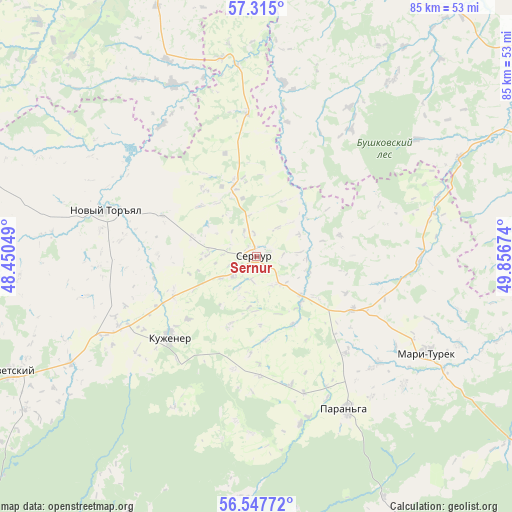
Sernur GPS coordinates[2]
56° 55' 59.988" North, 49° 9' 12.996" East
| Map corner | latitude | longitude |
|---|---|---|
| Upper-left | 57.315°, | 48.45049° |
| Center: | 56.93333°, | 49.15361° |
| Lower-right: | 56.54772°, | 49.85674° |
| Map W x H: | 85.3×85.3 km | = 53×53mi |
| max Lat: | 73.50819° ⇑23.4% North |
| Sernur: | 56.93333° |
| min Lat: | ⇓76.6% South 41.28413° |
| min Long | Sernur | max Long |
| -179.12198° | 49.15361° | 179.35046° |
| W 61%⇐ | ⇒39% E |
Elevation
Elevation of Sernur is 157 m = 515 ft, and this is 45.6 m = 150 ft below average elevation for this country.
| Max E: |
2518 m = 8261 ft | 44.7% |
| Avg. | 202.6 m = 665 ft | |
| Sernur | 157 m = 515 ft | |
Min E: |
-28 m = -92 ft | 55.3% |
See also: Russia elevation on elevation.city.
Geographical zone
Sernur is located in North temperate zone (between Tropic of Cancer and the Arctic Circle). Distance of this North polar circle is 1070.8 km =665.4 mi to North.| Distance of | km | miles | from Sernur |
|---|---|---|---|
| North Pole | 3676.7 | 2284.6 | to North |
| Arctic Circle | 1070.8 | 665.4 | to North |
| Tropic Cancer | 3724.5 | 2314.3 | to South |
| Equator | 6330.4 | 3933.5 | to South |


Nearby cities:
15 places around Sernur: (largest is in red/bold)
• Arkul’
66.2 km =41.1 mi,  54°
54°
• Kuzhener
20 km =12.4 mi,  227°
227°
• Mari-Turek
32.7 km =20.3 mi,  119°
119°
• Mariyets
62.5 km =38.8 mi,  138°
138°
• Medvedok
73.4 km =45.6 mi, 46°
• Mochalishche
82.9 km =51.5 mi,  216°
216°
• Morki
56.8 km =35.3 mi,  189°
189°
• Orshanka
76.5 km =47.5 mi,  268°
268°
• Paran’ga
29.7 km =18.5 mi,  149°
149°
• Pizhanka
69.2 km =43 mi,  327°
327°
• Sovetsk
73.4 km =45.6 mi,  350°
350°
• Sovetskiy
45.6 km =28.3 mi,  244°
244°
• Surok
83 km =51.6 mi, 229°
• Urzhum
55 km =34.2 mi,  68°
68°
• Yoshkar-Ola
83.6 km =51.9 mi,  246°
246°
Sources, notices
• [Note1] Compared only with cities in Russia existing in our database
• [Src1] Map data: © OpenStreetMap contributors (CC-BY-SA)
• [Src2] Other city data from geonames.org with taken over terms of usage.
• [Src3] Geographical zone / Annual Mean Temperature by Robert A. Rohde @ Wikipedia
