Mari-Turek geodata
Mari-Turek (Mariy-El Republic) is a populated place; located in Russia in Europe/Moscow (GMT+3) time zone. With population of 5,900 people, there are 2296 cities with bigger population in this country. Compared to other cities in Russia, 75.2% of cities are located further ↓South; 61.5% of cities are located further ←West and 57.3% of cities have higher elevation than Mari-Turek. Note1


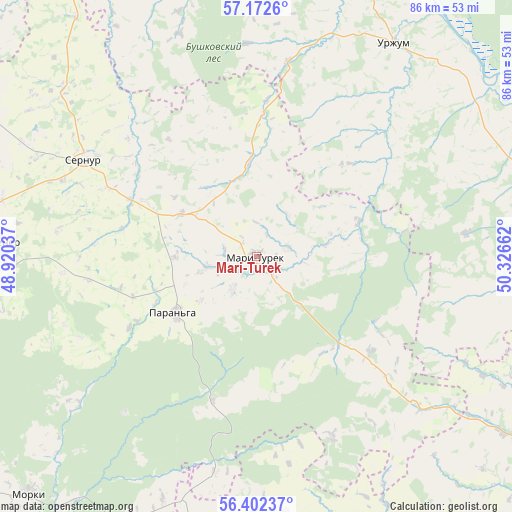
Mari-Turek GPS coordinates[2]
56° 47' 22.056" North, 49° 37' 24.564" East
| Map corner | latitude | longitude |
|---|---|---|
| Upper-left | 57.1726°, | 48.92037° |
| Center: | 56.78946°, | 49.62349° |
| Lower-right: | 56.40237°, | 50.32662° |
| Map W x H: | 85.6×85.6 km | = 53.2×53.2mi |
| max Lat: | 73.50819° ⇑24.8% North |
| Mari-Turek: | 56.78946° |
| min Lat: | ⇓75.2% South 41.28413° |
| min Long | Mari-Turek | max Long |
| -179.12198° | 49.62349° | 179.35046° |
| W 61.5%⇐ | ⇒38.5% E |
Elevation
Elevation of Mari-Turek is 130 m = 427 ft, and this is 72.6 m = 238 ft below average elevation for this country.
| Max E: |
2518 m = 8261 ft | 57.3% |
| Avg. | 202.6 m = 665 ft | |
| Mari-Turek | 130 m = 427 ft | |
Min E: |
-28 m = -92 ft | 42.7% |
See also: Russia elevation on elevation.city.
Geographical zone
Mari-Turek is located in North temperate zone (between Tropic of Cancer and the Arctic Circle). Distance of this North polar circle is 1086.8 km =675.3 mi to North.| Distance of | km | miles | from Mari-Turek |
|---|---|---|---|
| North Pole | 3692.7 | 2294.5 | to North |
| Arctic Circle | 1086.8 | 675.3 | to North |
| Tropic Cancer | 3708.5 | 2304.4 | to South |
| Equator | 6314.4 | 3923.6 | to South |


Nearby cities:
15 places around Mari-Turek: (largest is in red/bold)
• Arkul’
60.3 km =37.5 mi,  24°
24°
• Arsk
79.2 km =49.2 mi,  168°
168°
• Baltasi
60.9 km =37.8 mi,  144°
144°
• Kil’mez’
89.3 km =55.5 mi,  78°
78°
• Kuzhener
43.3 km =26.9 mi,  273°
273°
• Malmyzh
71.3 km =44.3 mi,  114°
114°
• Mariyets
33.3 km =20.7 mi,  156°
156°
• Medvedok
71.2 km =44.2 mi, 20°
• Morki
55.5 km =34.5 mi,  223°
223°
• Nolinsk
87.7 km =54.5 mi,  12°
12°
• Paran’ga
16.4 km =10.2 mi,  234°
234°
• Sernur
32.7 km =20.3 mi,  299°
299°
• Shemordan
82.2 km =51.1 mi, 144°
• Sovetskiy
70 km =43.5 mi, 267°
• Urzhum
42.7 km =26.5 mi,  32°
32°
Sources, notices
• [Note1] Compared only with cities in Russia existing in our database
• [Src1] Map data: © OpenStreetMap contributors (CC-BY-SA)
• [Src2] Other city data from geonames.org with taken over terms of usage.
• [Src3] Geographical zone / Annual Mean Temperature by Robert A. Rohde @ Wikipedia
