Semibratovo geodata
Semibratovo (Jaroslavl) is a populated place; located in Russia in Europe/Moscow (GMT+3) time zone. With population of 7,511 people, there are 1901 cities with bigger population in this country. Compared to other cities in Russia, 79% of cities are located further ↓South; 69.9% of cities are located further →East and 70.6% of cities have higher elevation than Semibratovo. Note1


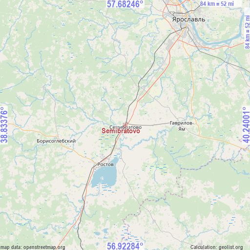
Semibratovo GPS coordinates[2]
57° 18' 16.596" North, 39° 32' 12.768" East
| Map corner | latitude | longitude |
|---|---|---|
| Upper-left | 57.68246°, | 38.83376° |
| Center: | 57.30461°, | 39.53688° |
| Lower-right: | 56.92284°, | 40.24001° |
| Map W x H: | 84.5×84.5 km | = 52.5×52.5mi |
| max Lat: | 73.50819° ⇑21% North |
| Semibratovo: | 57.30461° |
| min Lat: | ⇓79% South 41.28413° |
| min Long | Semibratovo | max Long |
| -179.12198° | 39.53688° | 179.35046° |
| W 30.1%⇐ | ⇒69.9% E |
Elevation
Elevation of Semibratovo is 101 m = 331 ft, and this is 101.6 m = 333 ft below average elevation for this country.
| Max E: |
2518 m = 8261 ft | 70.6% |
| Avg. | 202.6 m = 665 ft | |
| Semibratovo | 101 m = 331 ft | |
Min E: |
-28 m = -92 ft | 29.4% |
See also: Russia elevation on elevation.city.
Geographical zone
Semibratovo is located in North temperate zone (between Tropic of Cancer and the Arctic Circle). Distance of this North polar circle is 1029.5 km =639.7 mi to North.| Distance of | km | miles | from Semibratovo |
|---|---|---|---|
| North Pole | 3635.4 | 2258.9 | to North |
| Arctic Circle | 1029.5 | 639.7 | to North |
| Tropic Cancer | 3765.8 | 2340 | to South |
| Equator | 6371.7 | 3959.2 | to South |


Nearby cities:
15 places around Semibratovo: (largest is in red/bold)
• Borisoglebskiy
23.8 km =14.8 mi,  257°
257°
• Burmakino
43.8 km =27.2 mi,  73°
73°
• Dubki
42.8 km =26.6 mi,  90°
90°
• Gavrilov-Yam
19 km =11.8 mi, 90°
• Il’inskoye-Khovanskoye
39.6 km =24.6 mi,  159°
159°
• Ishnya
16.5 km =10.3 mi,  220°
220°
• Kolenovo
44.2 km =27.5 mi,  208°
208°
• Krasnyye Tkachi
24.7 km =15.3 mi,  32°
32°
• Kurba
28.6 km =17.8 mi,  355°
355°
• Nagornyy
33.8 km =21 mi, 32°
• Petrovsk
36.5 km =22.7 mi, 206°
• Porech’ye-Rybnoye
24.8 km =15.4 mi,  201°
201°
• Rostov
14.6 km =9.1 mi, 210°
• Tunoshna
44.3 km =27.5 mi,  52°
52°
• Yaroslavl
41.4 km =25.7 mi, 29°
Sources, notices
• [Note1] Compared only with cities in Russia existing in our database
• [Src1] Map data: © OpenStreetMap contributors (CC-BY-SA)
• [Src2] Other city data from geonames.org with taken over terms of usage.
• [Src3] Geographical zone / Annual Mean Temperature by Robert A. Rohde @ Wikipedia
