Tunoshna geodata
Tunoshna (Jaroslavl) is a populated place; located in Russia in Europe/Moscow (GMT+3) time zone. With population of 3,152 people, there are 3644 cities with bigger population in this country. Compared to other cities in Russia, 80.2% of cities are located further ↓South; 66.9% of cities are located further →East and 74.4% of cities have higher elevation than Tunoshna. Note1


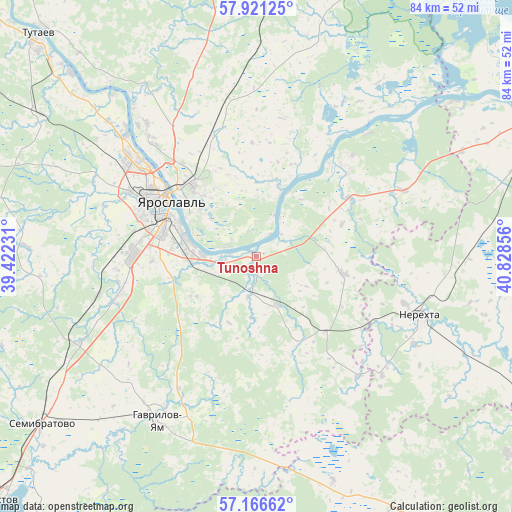
Tunoshna GPS coordinates[2]
57° 32' 45.204" North, 40° 7' 31.548" East
| Map corner | latitude | longitude |
|---|---|---|
| Upper-left | 57.92125°, | 39.42231° |
| Center: | 57.54589°, | 40.12543° |
| Lower-right: | 57.16662°, | 40.82856° |
| Map W x H: | 83.9×83.9 km | = 52.1×52.1mi |
| max Lat: | 73.50819° ⇑19.8% North |
| Tunoshna: | 57.54589° |
| min Lat: | ⇓80.2% South 41.28413° |
| min Long | Tunoshna | max Long |
| -179.12198° | 40.12543° | 179.35046° |
| W 33.1%⇐ | ⇒66.9% E |
Elevation
Elevation of Tunoshna is 90 m = 295 ft, and this is 112.6 m = 369 ft below average elevation for this country.
| Max E: |
2518 m = 8261 ft | 74.4% |
| Avg. | 202.6 m = 665 ft | |
| Tunoshna | 90 m = 295 ft | |
Min E: |
-28 m = -92 ft | 25.6% |
See also: Russia elevation on elevation.city.
Geographical zone
Tunoshna is located in North temperate zone (between Tropic of Cancer and the Arctic Circle). Distance of this North polar circle is 1002.7 km =623 mi to North.| Distance of | km | miles | from Tunoshna |
|---|---|---|---|
| North Pole | 3608.6 | 2242.3 | to North |
| Arctic Circle | 1002.7 | 623 | to North |
| Tropic Cancer | 3792.6 | 2356.6 | to South |
| Equator | 6398.5 | 3975.8 | to South |


Nearby cities:
15 places around Tunoshna: (largest is in red/bold)
• Burmakino
15.8 km =9.8 mi,  155°
155°
• Dubki
28.3 km =17.6 mi, 164°
• Gavrilov-Yam
31.6 km =19.6 mi,  210°
210°
• Konstantinovskiy
44.8 km =27.8 mi,  314°
314°
• Kosmynino
38.3 km =23.8 mi,  84°
84°
• Krasnyy Profintern
28.8 km =17.9 mi,  39°
39°
• Krasnyye Tkachi
22.8 km =14.2 mi,  254°
254°
• Kurba
37.5 km =23.3 mi,  272°
272°
• Levashevo
26.2 km =16.3 mi,  65°
65°
• Nagornyy
17.2 km =10.7 mi,  275°
275°
• Nekrasovskoye
20.4 km =12.7 mi, 44°
• Nerekhta
28.5 km =17.7 mi,  109°
109°
• Pistsovo
47.5 km =29.5 mi,  149°
149°
• Semibratovo
44.3 km =27.5 mi,  232°
232°
• Yaroslavl
17.7 km =11 mi,  301°
301°
Sources, notices
• [Note1] Compared only with cities in Russia existing in our database
• [Src1] Map data: © OpenStreetMap contributors (CC-BY-SA)
• [Src2] Other city data from geonames.org with taken over terms of usage.
• [Src3] Geographical zone / Annual Mean Temperature by Robert A. Rohde @ Wikipedia
