Borisoglebskiy geodata
Borisoglebskiy (Jaroslavl) is a populated place; located in Russia in Europe/Moscow (GMT+3) time zone. With population of 5,832 people, there are 2323 cities with bigger population in this country. Compared to other cities in Russia, 78.8% of cities are located further ↓South; 71.5% of cities are located further →East and 62% of cities have higher elevation than Borisoglebskiy. Note1


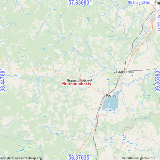
Borisoglebskiy GPS coordinates[2]
57° 15' 30.96" North, 39° 9' 2.88" East
| Map corner | latitude | longitude |
|---|---|---|
| Upper-left | 57.63693°, | 38.44768° |
| Center: | 57.2586°, | 39.1508° |
| Lower-right: | 56.87635°, | 39.85393° |
| Map W x H: | 84.6×84.6 km | = 52.6×52.6mi |
| max Lat: | 73.50819° ⇑21.2% North |
| Borisoglebskiy: | 57.2586° |
| min Lat: | ⇓78.8% South 41.28413° |
| min Long | Borisoglebskiy | max Long |
| -179.12198° | 39.1508° | 179.35046° |
| W 28.5%⇐ | ⇒71.5% E |
Elevation
Elevation of Borisoglebskiy is 120 m = 394 ft, and this is 82.6 m = 271 ft below average elevation for this country.
| Max E: |
2518 m = 8261 ft | 62% |
| Avg. | 202.6 m = 665 ft | |
| Borisoglebskiy | 120 m = 394 ft | |
Min E: |
-28 m = -92 ft | 38% |
See also: Russia elevation on elevation.city.
Geographical zone
Borisoglebskiy is located in North temperate zone (between Tropic of Cancer and the Arctic Circle). Distance of this North polar circle is 1034.6 km =642.9 mi to North.| Distance of | km | miles | from Borisoglebskiy |
|---|---|---|---|
| North Pole | 3640.5 | 2262.1 | to North |
| Arctic Circle | 1034.6 | 642.9 | to North |
| Tropic Cancer | 3760.6 | 2336.7 | to South |
| Equator | 6366.6 | 3956 | to South |


Nearby cities:
15 places around Borisoglebskiy: (largest is in red/bold)
• Bol’shaya Brembola
58.6 km =36.4 mi,  194°
194°
• Bol’shoye Selo
52.7 km =32.7 mi,  345°
345°
• Gavrilov-Yam
42.5 km =26.4 mi,  83°
83°
• Il’inskoye-Khovanskoye
49.1 km =30.5 mi,  130°
130°
• Ishnya
14.7 km =9.1 mi,  120°
120°
• Ivanovskoye
44 km =27.3 mi, 189°
• Kolenovo
34 km =21.1 mi,  175°
175°
• Krasnyye Tkachi
44.7 km =27.8 mi,  54°
54°
• Kurba
39.5 km =24.5 mi,  31°
31°
• Nagornyy
53.2 km =33.1 mi, 50°
• Petrovsk
28.5 km =17.7 mi,  165°
165°
• Porech’ye-Rybnoye
22.7 km =14.1 mi,  141°
141°
• Rostov
17.5 km =10.9 mi, 115°
• Semibratovo
23.8 km =14.8 mi, 77°
• Uglich
57.5 km =35.7 mi,  301°
301°
Sources, notices
• [Note1] Compared only with cities in Russia existing in our database
• [Src1] Map data: © OpenStreetMap contributors (CC-BY-SA)
• [Src2] Other city data from geonames.org with taken over terms of usage.
• [Src3] Geographical zone / Annual Mean Temperature by Robert A. Rohde @ Wikipedia
