Rudnichnyy geodata
Rudnichnyy (Perm) is a populated place; located in Russia in Asia/Yekaterinburg (GMT+5) time zone. With population of 875 people, there are 4718 cities with bigger population in this country. Compared to other cities in Russia, 86.5% of cities are located further ↓South; 69.1% of cities are located further ←West and 88.4% of cities have lower elevation than Rudnichnyy. Note1


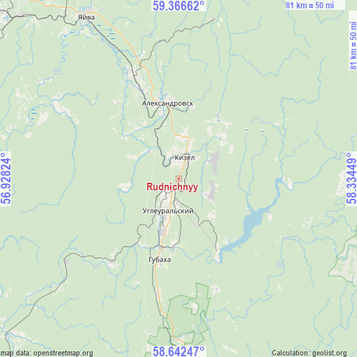
Rudnichnyy GPS coordinates[2]
59° 0' 23.22" North, 57° 37' 52.896" East
| Map corner | latitude | longitude |
|---|---|---|
| Upper-left | 59.36662°, | 56.92824° |
| Center: | 59.00645°, | 57.63136° |
| Lower-right: | 58.64247°, | 58.33449° |
| Map W x H: | 80.5×80.5 km | = 50×50mi |
| max Lat: | 73.50819° ⇑13.5% North |
| Rudnichnyy: | 59.00645° |
| min Lat: | ⇓86.5% South 41.28413° |
| min Long | Rudnichnyy | max Long |
| -179.12198° | 57.63136° | 179.35046° |
| W 69.1%⇐ | ⇒30.9% E |
Elevation
Elevation of Rudnichnyy is 408 m = 1339 ft, and this is 205.4 m = 674 ft above average elevation for this country.
| Max E: |
2518 m = 8261 ft | 11.6% |
| Rudnichnyy | 408 m 1339 ft | |
| Avg. | 202.6 m = 665 ft | |
Min E: |
-28 m = -92 ft | 88.4% |
See also: Russia elevation on elevation.city.
Geographical zone
Rudnichnyy is located in North temperate zone (between Tropic of Cancer and the Arctic Circle). Distance of this North polar circle is 840.3 km =522.1 mi to North.| Distance of | km | miles | from Rudnichnyy |
|---|---|---|---|
| North Pole | 3446.2 | 2141.4 | to North |
| Arctic Circle | 840.3 | 522.1 | to North |
| Tropic Cancer | 3955 | 2457.5 | to South |
| Equator | 6560.9 | 4076.8 | to South |


Nearby cities:
15 places around Rudnichnyy: (largest is in red/bold)
• Aleksandrovsk
17.2 km =10.7 mi,  348°
348°
• Berezniki
64.3 km =40 mi,  314°
314°
• Gremyachinsk
51.2 km =31.8 mi,  165°
165°
• Gubakha
19.2 km =11.9 mi,  193°
193°
• Kizel
4.6 km =2.9 mi,  11°
11°
• Nagornskiy
26.9 km =16.7 mi, 190°
• Severnyy-Kospashskiy
13.5 km =8.4 mi,  46°
46°
• Shakhta
9.5 km =5.9 mi, 9°
• Shirokovskiy
20.4 km =12.7 mi,  154°
154°
• Shumikhinskiy
29.3 km =18.2 mi, 173°
• Ugleural’skiy
7.2 km =4.5 mi,  197°
197°
• Usol’ye
70.9 km =44.1 mi, 310°
• Yayva
42.2 km =26.2 mi,  329°
329°
• Yubileynyy
26.7 km =16.6 mi,  161°
161°
• Yuzhnyy-Kospashskiy
8.2 km =5.1 mi,  117°
117°
Sources, notices
• [Note1] Compared only with cities in Russia existing in our database
• [Src1] Map data: © OpenStreetMap contributors (CC-BY-SA)
• [Src2] Other city data from geonames.org with taken over terms of usage.
• [Src3] Geographical zone / Annual Mean Temperature by Robert A. Rohde @ Wikipedia
