Yayva geodata
Yayva (Perm) is a populated place; located in Russia in Asia/Yekaterinburg (GMT+5) time zone. With population of 10,615 people, there are 1428 cities with bigger population in this country. Compared to other cities in Russia, 87.3% of cities are located further ↓South; 68.8% of cities are located further ←West and 53.6% of cities have higher elevation than Yayva. Note1


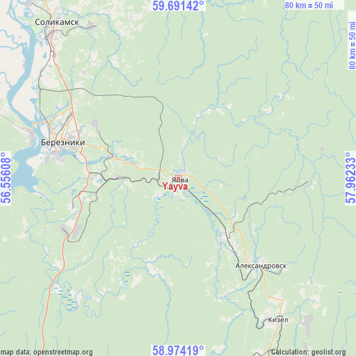
Yayva GPS coordinates[2]
59° 20' 4.92" North, 57° 15' 33.12" East
| Map corner | latitude | longitude |
|---|---|---|
| Upper-left | 59.69142°, | 56.55608° |
| Center: | 59.3347°, | 57.2592° |
| Lower-right: | 58.97419°, | 57.96233° |
| Map W x H: | 79.7×79.7 km | = 49.5×49.5mi |
| max Lat: | 73.50819° ⇑12.7% North |
| Yayva: | 59.3347° |
| min Lat: | ⇓87.3% South 41.28413° |
| min Long | Yayva | max Long |
| -179.12198° | 57.2592° | 179.35046° |
| W 68.8%⇐ | ⇒31.2% E |
Elevation
Elevation of Yayva is 137 m = 449 ft, and this is 65.6 m = 215 ft below average elevation for this country.
| Max E: |
2518 m = 8261 ft | 53.6% |
| Avg. | 202.6 m = 665 ft | |
| Yayva | 137 m = 449 ft | |
Min E: |
-28 m = -92 ft | 46.4% |
See also: Russia elevation on elevation.city.
Geographical zone
Yayva is located in North temperate zone (between Tropic of Cancer and the Arctic Circle). Distance of this North polar circle is 803.8 km =499.5 mi to North.| Distance of | km | miles | from Yayva |
|---|---|---|---|
| North Pole | 3409.7 | 2118.7 | to North |
| Arctic Circle | 803.8 | 499.5 | to North |
| Tropic Cancer | 3991.5 | 2480.2 | to South |
| Equator | 6597.4 | 4099.4 | to South |


Nearby cities:
15 places around Yayva: (largest is in red/bold)
• Aleksandrovsk
26.4 km =16.4 mi,  138°
138°
• Berezniki
26.2 km =16.3 mi,  288°
288°
• Gubakha
57.7 km =35.9 mi,  163°
163°
• Kizel
38.9 km =24.2 mi,  145°
145°
• Nagornskiy
65 km =40.4 mi,  165°
165°
• Rudnichnyy
42.2 km =26.2 mi, 149°
• Severnyy-Kospashskiy
41.3 km =25.7 mi,  131°
131°
• Shakhta
35.4 km =22 mi, 140°
• Shirokovskiy
62.6 km =38.9 mi, 151°
• Shumikhinskiy
70.1 km =43.6 mi, 159°
• Solikamsk
43.1 km =26.8 mi,  319°
319°
• Ugleural’skiy
47.4 km =29.5 mi, 156°
• Usol’ye
33.9 km =21.1 mi, 286°
• Yubileynyy
68.6 km =42.6 mi, 154°
• Yuzhnyy-Kospashskiy
49.3 km =30.6 mi, 144°
Sources, notices
• [Note1] Compared only with cities in Russia existing in our database
• [Src1] Map data: © OpenStreetMap contributors (CC-BY-SA)
• [Src2] Other city data from geonames.org with taken over terms of usage.
• [Src3] Geographical zone / Annual Mean Temperature by Robert A. Rohde @ Wikipedia
