Reshetikha geodata
Reshetikha (Nizhny Novgorod Oblast) is a populated place; located in Russia in Europe/Moscow (GMT+3) time zone. With population of 6,710 people, there are 2071 cities with bigger population in this country. Compared to other cities in Russia, 69.5% of cities are located further ↓South; 55.4% of cities are located further →East and 71.5% of cities have higher elevation than Reshetikha. Note1


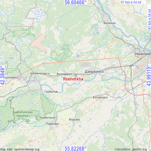
Reshetikha GPS coordinates[2]
56° 12' 56.376" North, 43° 17' 16.872" East
| Map corner | latitude | longitude |
|---|---|---|
| Upper-left | 56.60466°, | 42.5849° |
| Center: | 56.21566°, | 43.28802° |
| Lower-right: | 55.82268°, | 43.99115° |
| Map W x H: | 86.9×86.9 km | = 54×54mi |
| max Lat: | 73.50819° ⇑30.5% North |
| Reshetikha: | 56.21566° |
| min Lat: | ⇓69.5% South 41.28413° |
| min Long | Reshetikha | max Long |
| -179.12198° | 43.28802° | 179.35046° |
| W 44.6%⇐ | ⇒55.4% E |
Elevation
Elevation of Reshetikha is 99 m = 325 ft, and this is 103.6 m = 340 ft below average elevation for this country.
| Max E: |
2518 m = 8261 ft | 71.5% |
| Avg. | 202.6 m = 665 ft | |
| Reshetikha | 99 m = 325 ft | |
Min E: |
-28 m = -92 ft | 28.5% |
See also: Russia elevation on elevation.city.
Geographical zone
Reshetikha is located in North temperate zone (between Tropic of Cancer and the Arctic Circle). Distance of this North polar circle is 1150.6 km =714.9 mi to North.| Distance of | km | miles | from Reshetikha |
|---|---|---|---|
| North Pole | 3756.5 | 2334.2 | to North |
| Arctic Circle | 1150.6 | 714.9 | to North |
| Tropic Cancer | 3644.7 | 2264.7 | to South |
| Equator | 6250.6 | 3883.9 | to South |


Nearby cities:
15 places around Reshetikha: (largest is in red/bold)
• Babino
20.8 km =12.9 mi,  86°
86°
• Berëzovaya Poyma
24.5 km =15.2 mi,  56°
56°
• Bogorodsk
18.6 km =11.6 mi,  131°
131°
• Dzerzhinsk
10.7 km =6.6 mi,  74°
74°
• Gorbatov
16.8 km =10.4 mi,  235°
235°
• Ilyinogorsk
20.7 km =12.9 mi,  273°
273°
• Mulino
24.2 km =15 mi,  289°
289°
• Novosmolinskiy
16.5 km =10.3 mi,  297°
297°
• Petryayevka
21.4 km =13.3 mi,  84°
84°
• Pyra
9.7 km =6 mi,  24°
24°
• Smolino
13.9 km =8.6 mi, 298°
• Volodarsk
6.4 km =4 mi, 285°
• Vorsma
25 km =15.5 mi,  182°
182°
• Yuganets
5.3 km =3.3 mi,  317°
317°
• Zhelnino
5 km =3.1 mi,  107°
107°
Sources, notices
• [Note1] Compared only with cities in Russia existing in our database
• [Src1] Map data: © OpenStreetMap contributors (CC-BY-SA)
• [Src2] Other city data from geonames.org with taken over terms of usage.
• [Src3] Geographical zone / Annual Mean Temperature by Robert A. Rohde @ Wikipedia
