Babino geodata
Babino (Nizhny Novgorod Oblast) is a populated place; located in Russia in Europe/Moscow (GMT+3) time zone. With population of 2,456 people, there are 3977 cities with bigger population in this country. Compared to other cities in Russia, 69.6% of cities are located further ↓South; 54.3% of cities are located further →East and 78.7% of cities have higher elevation than Babino. Note1


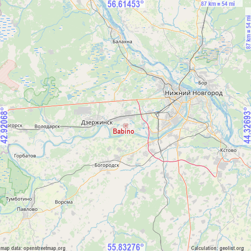
Babino GPS coordinates[2]
56° 13' 32.304" North, 43° 37' 25.68" East
| Map corner | latitude | longitude |
|---|---|---|
| Upper-left | 56.61453°, | 42.92068° |
| Center: | 56.22564°, | 43.6238° |
| Lower-right: | 55.83276°, | 44.32693° |
| Map W x H: | 86.9×86.9 km | = 54×54mi |
| max Lat: | 73.50819° ⇑30.4% North |
| Babino: | 56.22564° |
| min Lat: | ⇓69.6% South 41.28413° |
| min Long | Babino | max Long |
| -179.12198° | 43.6238° | 179.35046° |
| W 45.7%⇐ | ⇒54.3% E |
Elevation
Elevation of Babino is 75 m = 246 ft, and this is 127.6 m = 419 ft below average elevation for this country.
| Max E: |
2518 m = 8261 ft | 78.7% |
| Avg. | 202.6 m = 665 ft | |
| Babino | 75 m = 246 ft | |
Min E: |
-28 m = -92 ft | 21.3% |
See also: Russia elevation on elevation.city.
Geographical zone
Babino is located in North temperate zone (between Tropic of Cancer and the Arctic Circle). Distance of this North polar circle is 1149.5 km =714.3 mi to North.| Distance of | km | miles | from Babino |
|---|---|---|---|
| North Pole | 3755.4 | 2333.5 | to North |
| Arctic Circle | 1149.5 | 714.3 | to North |
| Tropic Cancer | 3645.8 | 2265.4 | to South |
| Equator | 6251.7 | 3884.6 | to South |


Nearby cities:
15 places around Babino: (largest is in red/bold)
• Berëzovaya Poyma
12.5 km =7.8 mi,  358°
358°
• Bogorodsk
15.1 km =9.4 mi,  207°
207°
• Bol’shoye Kozino
20.6 km =12.8 mi,  15°
15°
• Burevestnik
13.6 km =8.5 mi,  131°
131°
• Dzerzhinsk
10.6 km =6.6 mi,  279°
279°
• Gavrilovka
6.2 km =3.9 mi,  83°
83°
• Gorbatovka
8.3 km =5.2 mi,  65°
65°
• Lukino
24 km =14.9 mi,  0°
0°
• Lyakhovo
22.2 km =13.8 mi,  87°
87°
• Maloye Kozino
23.9 km =14.9 mi,  7°
7°
• Pervoye Maya
21.2 km =13.2 mi, 4°
• Petryayevka
1 km =0.6 mi,  34°
34°
• Pyra
18.4 km =11.4 mi,  294°
294°
• Reshetikha
20.8 km =12.9 mi,  266°
266°
• Zhelnino
16.2 km =10.1 mi,  260°
260°
Sources, notices
• [Note1] Compared only with cities in Russia existing in our database
• [Src1] Map data: © OpenStreetMap contributors (CC-BY-SA)
• [Src2] Other city data from geonames.org with taken over terms of usage.
• [Src3] Geographical zone / Annual Mean Temperature by Robert A. Rohde @ Wikipedia
