Gorbatov geodata
Gorbatov (Nizhny Novgorod Oblast) is a populated place; located in Russia in Europe/Moscow (GMT+3) time zone. With population of 1,934 people, there are 4202 cities with bigger population in this country. Compared to other cities in Russia, 68.3% of cities are located further ↓South; 56.5% of cities are located further →East and 61.2% of cities have lower elevation than Gorbatov. Note1


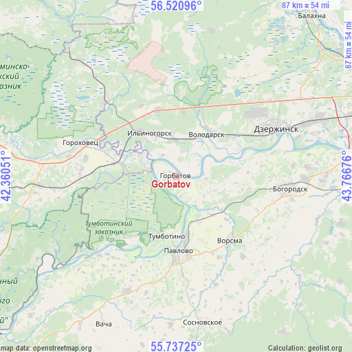
Gorbatov GPS coordinates[2]
56° 7' 51.96" North, 43° 3' 49.068" East
| Map corner | latitude | longitude |
|---|---|---|
| Upper-left | 56.52096°, | 42.36051° |
| Center: | 56.1311°, | 43.06363° |
| Lower-right: | 55.73725°, | 43.76676° |
| Map W x H: | 87.1×87.1 km | = 54.1×54.1mi |
| max Lat: | 73.50819° ⇑31.7% North |
| Gorbatov: | 56.1311° |
| min Lat: | ⇓68.3% South 41.28413° |
| min Long | Gorbatov | max Long |
| -179.12198° | 43.06363° | 179.35046° |
| W 43.5%⇐ | ⇒56.5% E |
Elevation
Elevation of Gorbatov is 172 m = 564 ft, and this is 30.6 m = 100 ft below average elevation for this country.
| Max E: |
2518 m = 8261 ft | 38.8% |
| Avg. | 202.6 m = 665 ft | |
| Gorbatov | 172 m = 564 ft | |
Min E: |
-28 m = -92 ft | 61.2% |
See also: Russia elevation on elevation.city.
Geographical zone
Gorbatov is located in North temperate zone (between Tropic of Cancer and the Arctic Circle). Distance of this North polar circle is 1160 km =720.8 mi to North.| Distance of | km | miles | from Gorbatov |
|---|---|---|---|
| North Pole | 3765.9 | 2340 | to North |
| Arctic Circle | 1160 | 720.8 | to North |
| Tropic Cancer | 3635.3 | 2258.9 | to South |
| Equator | 6241.2 | 3878.1 | to South |


Nearby cities:
15 places around Gorbatov: (largest is in red/bold)
• Galitsy
14.4 km =8.9 mi,  290°
290°
• Gorokhovets
24.2 km =15 mi, 288°
• Ilyinogorsk
12.7 km =7.9 mi,  327°
327°
• Mulino
19.7 km =12.2 mi, 333°
• Novosmolinskiy
17 km =10.6 mi,  357°
357°
• Pavlovo
18.1 km =11.2 mi,  174°
174°
• Reshetikha
16.8 km =10.4 mi,  55°
55°
• Smolino
16.1 km =10 mi,  6°
6°
• Taremskoye
22.5 km =14 mi,  183°
183°
• Tsentral’nyy
25.1 km =15.6 mi,  317°
317°
• Tumbotino
14.9 km =9.3 mi,  189°
189°
• Volodarsk
13.5 km =8.4 mi,  34°
34°
• Vorsma
20.3 km =12.6 mi,  140°
140°
• Yuganets
16.9 km =10.5 mi,  37°
37°
• Zhelnino
20.3 km =12.6 mi,  67°
67°
Sources, notices
• [Note1] Compared only with cities in Russia existing in our database
• [Src1] Map data: © OpenStreetMap contributors (CC-BY-SA)
• [Src2] Other city data from geonames.org with taken over terms of usage.
• [Src3] Geographical zone / Annual Mean Temperature by Robert A. Rohde @ Wikipedia
